IMAGES TAKEN NEAR TO
Little Hervells Court, CHEPSTOW, NP16 5FF
Introduction
This page details the photographs taken nearby to Little Hervells Court, NP16 5FF by members of the Geograph project.
The Geograph project started in 2005 with the aim of publishing, organising and preserving representative images for every square kilometre of Great Britain, Ireland and the Isle of Man.

There are currently over 7.5m images from over14,400 individuals and you can help contribute to the project by visiting https://www.geograph.org.uk
Image Map
Images are licensed for reuse under creativecommons.org/licenses/by-sa/2.0
Notes
- Clicking on the map will re-center to the selected point.
- The higher the marker number, the further away the image location is from the centre of the postcode.
Image Listing (358 Images Found)
Images are licensed for reuse under creativecommons.org/licenses/by-sa/2.0
Image
Details
Distance
1
![Chepstow houses [30]](https://s3.geograph.org.uk/geophotos/07/35/68/7356887_b44841fe_120x120.jpg)
Chepstow houses [30]
Lower Hardwick, Hardwick Hill, was built circa 1813 as part of the Mount Pleasant development following the creation of a new road in 1808 'for easing the Hill'. Constructed, in a double pile plan, of stuccoed brick, lined to simulate ashlar, under a hipped slate roof. Listed, grade II, with details at: https://cadwpublic-api.azurewebsites.net/reports/listedbuilding/FullReport?lang=&id=2527
Chepstow, the most easterly town in Wales, is located on the tidal River Wye, some 3 miles above its confluence with the River Severn. There is evidence of continuous human occupation from the Mesolithic period. The town grew in importance when the Normans erected a castle at what was the lowest bridging point of the River Wye. The town flourished as a port, being exempt from English taxation, and it mainly traded in timber and bark from the Wye Valley. The town became an important centre for tourism from the late eighteenth century.
Image: © Michael Dibb
Taken: 2 Sep 2022
0.02 miles
2
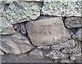
Ordnance Survey Cut Mark
This OS cut mark can be found on the wall north side of Hardwick Hill. It marks a point 76.017m above mean sea level.
Image: © Adrian Dust
Taken: 1 Feb 2022
0.02 miles
3
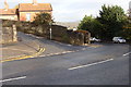
Chepstow : Steep Street
A road off the A48.
Image: © Lewis Clarke
Taken: 22 Mar 2023
0.03 miles
4
![Chepstow houses [31]](https://s2.geograph.org.uk/geophotos/07/35/68/7356890_66b9880c_120x120.jpg)
Chepstow houses [31]
Only a side elevation is viewable of number 1 Hardwick House, Hardwick Hill. It is part of a complex of four dwellings, built in the early to mid 19th century as part of the development of the area following the creation of a new road in 1808 'for easing the Hill'. Formerly called Oak field and later Hardwick Hall. It was a private school from 1930s until the later 20th century. Constructed of rendered brick under a hipped slate roof. Listed, grade II, with details at: https://cadwpublic-api.azurewebsites.net/reports/listedbuilding/FullReport?lang=&id=27118
Chepstow, the most easterly town in Wales, is located on the tidal River Wye, some 3 miles above its confluence with the River Severn. There is evidence of continuous human occupation from the Mesolithic period. The town grew in importance when the Normans erected a castle at what was the lowest bridging point of the River Wye. The town flourished as a port, being exempt from English taxation, and it mainly traded in timber and bark from the Wye Valley. The town became an important centre for tourism from the late eighteenth century.
Image: © Michael Dibb
Taken: 2 Sep 2022
0.04 miles
5
![Chepstow houses [32]](https://s0.geograph.org.uk/geophotos/07/35/68/7356892_c25f7210_120x120.jpg)
Chepstow houses [32]
Number 2 Hardwick House, Hardwick Hill, seen here, and number 3 Hardwick House Image are part of a complex of four dwellings. Number 2 faces the main road, number 3 is at right angles but shares a side frontage with number 2. Built in the early to mid 19th century as part of the development of the area following the creation of a new road in 1808 'for easing the Hill'. Formerly called Oak field and later Hardwick Hall. Constructed of rendered brick under a hipped slate roof. Listed, grade II, with details at: https://cadwpublic-api.azurewebsites.net/reports/listedbuilding/FullReport?lang=&id=27118
Chepstow, the most easterly town in Wales, is located on the tidal River Wye, some 3 miles above its confluence with the River Severn. There is evidence of continuous human occupation from the Mesolithic period. The town grew in importance when the Normans erected a castle at what was the lowest bridging point of the River Wye. The town flourished as a port, being exempt from English taxation, and it mainly traded in timber and bark from the Wye Valley. The town became an important centre for tourism from the late eighteenth century.
Image: © Michael Dibb
Taken: 2 Sep 2022
0.04 miles
6
![Chepstow houses [33]](https://s2.geograph.org.uk/geophotos/07/35/68/7356894_df3ad791_120x120.jpg)
Chepstow houses [33]
Number 3 Hardwick House, Hardwick Hill, seen here, and number 2 Hardwick House Image are part of a complex of four dwellings. Number 2 faces the main road, number 3 is at right angles but shares a side frontage with number 2. Built in the early to mid 19th century as part of the development of the area following the creation of a new road in 1808 'for easing the Hill'. Formerly called Oak field and later Hardwick Hall. Constructed of rendered brick under a hipped slate roof. Listed, grade II, with details at: https://cadwpublic-api.azurewebsites.net/reports/listedbuilding/FullReport?lang=&id=27119
Chepstow, the most easterly town in Wales, is located on the tidal River Wye, some 3 miles above its confluence with the River Severn. There is evidence of continuous human occupation from the Mesolithic period. The town grew in importance when the Normans erected a castle at what was the lowest bridging point of the River Wye. The town flourished as a port, being exempt from English taxation, and it mainly traded in timber and bark from the Wye Valley. The town became an important centre for tourism from the late eighteenth century.
Image: © Michael Dibb
Taken: 2 Sep 2022
0.04 miles
7
![Chepstow houses [29]](https://s2.geograph.org.uk/geophotos/07/35/68/7356886_6e21d603_120x120.jpg)
Chepstow houses [29]
Ashfield House, Hardwick Hill, was built circa 1830 with additions made about 1890. The building became derelict in the late 20th century and was refurbished and converted into apartments. There are two gabled ranges and a later, smaller gabled range. Constructed of rendered brick with freestone dressings under slate roofs. Listed, grade II, with details at: https://cadwpublic-api.azurewebsites.net/reports/listedbuilding/FullReport?lang=&id=2794
Chepstow, the most easterly town in Wales, is located on the tidal River Wye, some 3 miles above its confluence with the River Severn. There is evidence of continuous human occupation from the Mesolithic period. The town grew in importance when the Normans erected a castle at what was the lowest bridging point of the River Wye. The town flourished as a port, being exempt from English taxation, and it mainly traded in timber and bark from the Wye Valley. The town became an important centre for tourism from the late eighteenth century.
Image: © Michael Dibb
Taken: 2 Sep 2022
0.05 miles
8
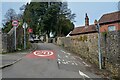
Big bend on hill - A48
This bend and hill are a particularly hazardous spot, being in very close proximity to the junction with Bulwark Road. The hill is a lot steeper than the picture implies.
Check out the 1:25,000 map for the exact relationship between the bend and the junction - the 1:50,000 map suggests they are at the same spot!
Image: © Ruth Sharville
Taken: 8 Nov 2008
0.05 miles
9
![Chepstow houses [34]](https://s3.geograph.org.uk/geophotos/07/35/68/7356895_7998d410_120x120.jpg)
Chepstow houses [34]
Stratheden, Number 4 Hardwick House, Hardwick Hill, is part of a complex of four dwellings. Built in the early to mid 19th century as part of the development of the area following the creation of a new road in 1808 'for easing the Hill'. Formerly called Oak field and later Hardwick Hall. Constructed of rendered brick under a hipped slate roof. Listed, grade II, with details at: https://cadwpublic-api.azurewebsites.net/reports/listedbuilding/FullReport?lang=&id=27120
Chepstow, the most easterly town in Wales, is located on the tidal River Wye, some 3 miles above its confluence with the River Severn. There is evidence of continuous human occupation from the Mesolithic period. The town grew in importance when the Normans erected a castle at what was the lowest bridging point of the River Wye. The town flourished as a port, being exempt from English taxation, and it mainly traded in timber and bark from the Wye Valley. The town became an important centre for tourism from the late eighteenth century.
Image: © Michael Dibb
Taken: 2 Sep 2022
0.05 miles
10
![Chepstow houses [35]](https://s0.geograph.org.uk/geophotos/07/35/68/7356896_43a428b3_120x120.jpg)
Chepstow houses [35]
High Trees, Vauxhall Lane, was built in the early or mid 19th century with later additions and alterations. Converted to become Chepstow Boys Grammar School in 1871 and to District Council offices in 1954. Constructed of rendered brick under a hipped slate roof behind a coped parapet. Some original internal features remain. Listed, grade II, with details at: https://cadwpublic-api.azurewebsites.net/reports/listedbuilding/FullReport?lang=&id=2588
Chepstow, the most easterly town in Wales, is located on the tidal River Wye, some 3 miles above its confluence with the River Severn. There is evidence of continuous human occupation from the Mesolithic period. The town grew in importance when the Normans erected a castle at what was the lowest bridging point of the River Wye. The town flourished as a port, being exempt from English taxation, and it mainly traded in timber and bark from the Wye Valley. The town became an important centre for tourism from the late eighteenth century.
Image: © Michael Dibb
Taken: 2 Sep 2022
0.05 miles