IMAGES TAKEN NEAR TO
Upper Church Street, CHEPSTOW, NP16 5EX
Introduction
This page details the photographs taken nearby to Upper Church Street, NP16 5EX by members of the Geograph project.
The Geograph project started in 2005 with the aim of publishing, organising and preserving representative images for every square kilometre of Great Britain, Ireland and the Isle of Man.

There are currently over 7.5m images from over14,400 individuals and you can help contribute to the project by visiting https://www.geograph.org.uk
Image Map
Images are licensed for reuse under creativecommons.org/licenses/by-sa/2.0
Notes
- Clicking on the map will re-center to the selected point.
- The higher the marker number, the further away the image location is from the centre of the postcode.
Image Listing (1218 Images Found)
Images are licensed for reuse under creativecommons.org/licenses/by-sa/2.0
Image
Details
Distance
1
![Chepstow buildings [67]](https://s1.geograph.org.uk/geophotos/07/35/78/7357861_93deff04_120x120.jpg)
Chepstow buildings [67]
Numbers 14 and 15 St Mary Street were built in the early 19th century with later alterations. The property was greatly remodelled in the early 21st century following a fire to form the frontage of extensive redevelopment to the rear. This former shop with living accommodation above is now an art studio/shop and offices. Constructed of rendered brick under a half-hipped slate roof. Listed, grade II, with details at: https://cadwpublic-api.azurewebsites.net/reports/listedbuilding/FullReport?lang=&id=2582
Image: © Michael Dibb
Taken: 3 Sep 2022
0.00 miles
2
![Chepstow buildings [66]](https://s3.geograph.org.uk/geophotos/07/35/78/7357859_72ad3c53_120x120.jpg)
Chepstow buildings [66]
Number 13 St Mary Street was built in the early or mid 19th century as a shop with living accommodation above. Constructed of rendered brick, lined to simulate ashlar, under a hipped slate roof. The shopfront is 20th century. Listed, grade II, with details at: https://cadwpublic-api.azurewebsites.net/reports/listedbuilding/FullReport?lang=&id=27094
Chepstow, the most easterly town in Wales, is located on the tidal River Wye, some 3 miles above its confluence with the River Severn. There is evidence of continuous human occupation from the Mesolithic period. The town grew in importance when the Normans erected a castle at what was the lowest bridging point of the River Wye. The town flourished as a port, being exempt from English taxation, and it mainly traded in timber and bark from the Wye Valley. The town became an important centre for tourism from the late eighteenth century.
Image: © Michael Dibb
Taken: 3 Sep 2022
0.01 miles
3
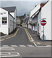
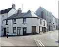
Upper Church Street, Chepstow
On the corner of Church Road, the No Entry sign is for Upper Church Street,
where double yellow lines on both sides indicate no parking at any time.
Image: © Jaggery
Taken: 7 Jul 2016
0.01 miles
4
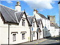
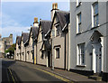
Almshouses, Chepstow
Old houses in the town centre of Chepstow. In the background is the tower of the parish church, St Mary.
http://www.chepstow.co.uk/Contents/Text/Index.asp?SiteId=137&SiteExtra=14722766&TopNavId=284&NavSideId=1194
Image: © Colin Smith
Taken: 25 Jul 2009
0.01 miles
5
![Chepstow buildings [65]](https://s2.geograph.org.uk/geophotos/07/35/78/7357858_c1edaf03_120x120.jpg)
Chepstow buildings [65]
Number 12 St Mary Street was built in 1905 for the Cooperative Wholesale Society of Manchester, with extensive stores to the rear. This tall, decorative building is constructed of painted brick with the gable facade of a mansard slate roof. , boarded eaves, brick end stack. Listed, grade II, with details at: https://cadwpublic-api.azurewebsites.net/reports/listedbuilding/FullReport?lang=&id=27093
Chepstow, the most easterly town in Wales, is located on the tidal River Wye, some 3 miles above its confluence with the River Severn. There is evidence of continuous human occupation from the Mesolithic period. The town grew in importance when the Normans erected a castle at what was the lowest bridging point of the River Wye. The town flourished as a port, being exempt from English taxation, and it mainly traded in timber and bark from the Wye Valley. The town became an important centre for tourism from the late eighteenth century.
Image: © Michael Dibb
Taken: 3 Sep 2022
0.01 miles
6
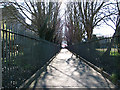
Chepstow St Mary's Church Railings
St Mary's church can be glimpsed to the left of this photograph. The churchyard is crossed by this well-used path to Lower Church Street. Artists hang their paintings on these railings every so often during the summer.
For history see Image
Image: © Roy Parkhouse
Taken: 5 Apr 2006
0.01 miles
7
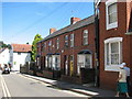
Chepstow - Badminton Villas in Bridge Street
Image: © Roy Parkhouse
Taken: 11 Aug 2007
0.01 miles
8
Former Glance Back shop, Chepstow
Located on the corner of Middle Street and Upper Church Street, viewed from Bridge Street. The shop closed on October 31st 2004, when the owners decided to focus entirely on an Internet presence. Glance Back had opened here in 1983, dealing in antiquarian and secondhand books, and a variety of collectables such as stamps, banknotes, coins, tokens, medals and badges.
Image: © Jaggery
Taken: 25 Mar 2011
0.01 miles
9
Chepstow - almshouses on Upper Church Street
For an alternative view, please see Image
Image: © Dave Bevis
Taken: 1 Oct 2011
0.01 miles
10
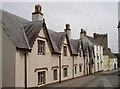
The Old Almshouses
These almshouses were founded in 1615 by Sir Walter Montague. Originally they houses five men and five women. They were later known as the old almshouses after Thomas Powis established another almshouse just a short distance away (see Image]), and were extensively rebuilt after WWII, but keeping the faĉades.
Image: © Neil Owen
Taken: 7 Aug 2013
0.01 miles