IMAGES TAKEN NEAR TO
Castle Street, USK, NP15 2DS
Introduction
This page details the photographs taken nearby to Castle Street, NP15 2DS by members of the Geograph project.
The Geograph project started in 2005 with the aim of publishing, organising and preserving representative images for every square kilometre of Great Britain, Ireland and the Isle of Man.

There are currently over 7.5m images from over14,400 individuals and you can help contribute to the project by visiting https://www.geograph.org.uk
Image Map
Images are licensed for reuse under creativecommons.org/licenses/by-sa/2.0
Notes
- Clicking on the map will re-center to the selected point.
- The higher the marker number, the further away the image location is from the centre of the postcode.
Image Listing (285 Images Found)
Images are licensed for reuse under creativecommons.org/licenses/by-sa/2.0
Image
Details
Distance
1
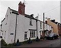
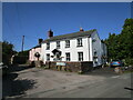
The Old Post Office, Raglan
Viewed across Castle Street from the corner of Primrose Green. Morton House is on the left.
The nameplate on the house next door, number 9 Castle Street, shows THE OLD POST OFFICE.
Image: © Jaggery
Taken: 5 Jan 2014
0.01 miles
2
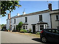
8 and 9 Castle Street, Raglan
Early nineteenth century houses https://cadwpublic-api.azurewebsites.net/reports/listedbuilding/FullReport?lang=&id=24729
Image: © Jonathan Thacker
Taken: 17 Sep 2020
0.01 miles
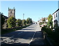
3
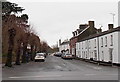
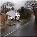
Castle Street Raglan
Viewed across High Street looking along Castle Street towards Primrose Green and Castle Hill.
Image: © Jaggery
Taken: 5 Jan 2014
0.01 miles
4
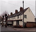
Old Vicarage, Raglan
Viewed across Castle Street. Now a private residence named The Malthouse, the house with the projecting entrance porch was until 1958 the residence for the vicar of St Cadoc's Church.
Image: © Jaggery
Taken: 5 Jan 2014
0.02 miles
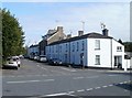
5
House on the corner of Primrose Green
Primrose Green is severed by the A40.
Image: © Jonathan Thacker
Taken: 17 Sep 2020
0.03 miles
6
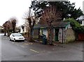
No longer convenient in Raglan
Viewed in early January 2014. A Monmouthshire County Council notice on the building shows that these Castle Street toilets have been closed since March 31st 2011.
Image: © Jaggery
Taken: 5 Jan 2014
0.03 miles
7
Monmouth Road bus stop, Raglan
Used by buses on the Newport to Monmouth and Abergavenny to Monmouth routes.
Image: © Jaggery
Taken: 2 Feb 2014
0.03 miles
8
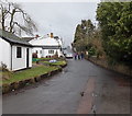
Castle Hill, Raglan
Looking SSW towards Castle Street and the centre of Raglan.
Image: © Jaggery
Taken: 2 Feb 2014
0.03 miles
9
Eastern edge of High Street, Raglan
Looking towards the centre of Raglan. On the left is St Cadoc's church. http://www.geograph.org.uk/photo/1385702
Image: © Jaggery
Taken: 26 Sep 2010
0.03 miles
10
Castle Street, Raglan
Viewed from the corner of High Street and Chepstow Road.
Image: © Jaggery
Taken: 26 Sep 2010
0.03 miles