IMAGES TAKEN NEAR TO
Bryngwyn, Raglan, USK, NP15 2BW
Introduction
This page details the photographs taken nearby to NP15 2BW by members of the Geograph project.
The Geograph project started in 2005 with the aim of publishing, organising and preserving representative images for every square kilometre of Great Britain, Ireland and the Isle of Man.

There are currently over 7.5m images from over14,400 individuals and you can help contribute to the project by visiting https://www.geograph.org.uk
Image Map
Images are licensed for reuse under creativecommons.org/licenses/by-sa/2.0
Notes
- Clicking on the map will re-center to the selected point.
- The higher the marker number, the further away the image location is from the centre of the postcode.
Image Listing (3 Images Found)
Images are licensed for reuse under creativecommons.org/licenses/by-sa/2.0
Image
Details
Distance
1
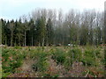
Working in Coed Robert
A woodman appears to be taking out weak saplings and brushwood.
In the foreground is a stand of Christmas trees for 2014.
Image: © Jonathan Billinger
Taken: 28 Jan 2010
0.12 miles
2
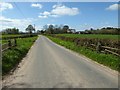
Road passing Court Robert
Country road passing Court Robert which can be seen on the right.
Image: © Philip Halling
Taken: 6 Apr 2017
0.22 miles
3
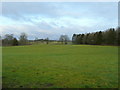
Monmouthshire pastoral scene
Looking north-west near Bryngwyn, Coed Robert to the right.
Sugarloaf, Y Fal, can just be seen in the centre distance.
Image: © Jonathan Billinger
Taken: 28 Jan 2010
0.22 miles