IMAGES TAKEN NEAR TO
Bryngwyn, Raglan, USK, NP15 2BG
Introduction
This page details the photographs taken nearby to NP15 2BG by members of the Geograph project.
The Geograph project started in 2005 with the aim of publishing, organising and preserving representative images for every square kilometre of Great Britain, Ireland and the Isle of Man.

There are currently over 7.5m images from over14,400 individuals and you can help contribute to the project by visiting https://www.geograph.org.uk
Image Map
Images are licensed for reuse under creativecommons.org/licenses/by-sa/2.0
Notes
- Clicking on the map will re-center to the selected point.
- The higher the marker number, the further away the image location is from the centre of the postcode.
Image Listing (13 Images Found)
Images are licensed for reuse under creativecommons.org/licenses/by-sa/2.0
Image
Details
Distance
1
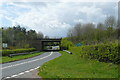
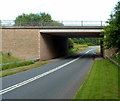
A40 bridge on Clytha Road
The 'new' A40 as I think of it, the dual carriageway between Raglan and Abergavenny, crosses the old road on this bridge. I decided to take the old road for a change and to explore some of the area that you normally just whiz through.
Image: © Graham Horn
Taken: 13 Apr 2012
0.10 miles
2
New over old
The A40 dual carriageway replaced the old single carriageway trunk road between Raglan and Abergavenny over thirty years ago.
Image: © Jonathan Billinger
Taken: 14 Dec 2009
0.11 miles
3
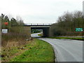
Road passing under the A40
A minor unclassified road passing under the A40 to the west of Raglan.
Image: © Philip Halling
Taken: 9 Jun 2012
0.11 miles
4
Road to Chapel Farm, Bryngwyn
Viewed from Clytha Road near Raglan.
Image: © Jaggery
Taken: 15 Jul 2012
0.15 miles
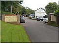
5
The Cripple Creek Inn near Raglan, Monmouthshire
One of those eateries that seems to always do well, despite the recent trading conditions even, serving up mid-market expectations to a happy clientele, mainly untroubled by considerations such as Michelin stars, celebrity chefs, gastro-pub terminology and spicy pricing. Hence its consistent performance.
Image: © Jeremy Bolwell
Taken: 24 Mar 2013
0.15 miles
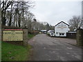
6
Entrance to The Cripple Creek Inn near Raglan
The country pub and restaurant is set back from the old Abergavenny road.
Image: © Jaggery
Taken: 15 Jul 2012
0.16 miles
7
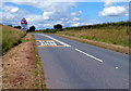
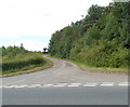
Slow down - bend ahead, Clytha Road near Raglan
This was formerly the route of the A40, which is now along a nearby dual carriageway. A 1940s map shows that there has been some minor realignments of the old A40 in this area, no doubt at the time of the construction of the dual carriageway.
Image: © Jaggery
Taken: 15 Jul 2012
0.17 miles
8
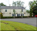
The Brooklands near Raglan
Detached cottage located between a garden centre http://www.geograph.org.uk/photo/3049259 and The Cripple Creek Inn. http://www.geograph.org.uk/photo/3049267
Image: © Jaggery
Taken: 15 Jul 2012
0.19 miles
9
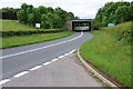
A40 crosses over Clytha Road near Raglan
Viewed along Clytha Road, sometimes referred to as the old Abergavenny Road, formerly the route of the A40 from Raglan. The A40 is now the newer dual carriageway route on the bridge.
Image: © Jaggery
Taken: 15 Jul 2012
0.19 miles
10
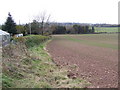
View west of Pen-y-parc
A footpath follows the edge of this field down to the A40 and beyond.
Image: © Jonathan Billinger
Taken: 8 Nov 2007
0.22 miles