IMAGES TAKEN NEAR TO
Llanbadoc, USK, NP15 1TQ
Introduction
This page details the photographs taken nearby to NP15 1TQ by members of the Geograph project.
The Geograph project started in 2005 with the aim of publishing, organising and preserving representative images for every square kilometre of Great Britain, Ireland and the Isle of Man.

There are currently over 7.5m images from over14,400 individuals and you can help contribute to the project by visiting https://www.geograph.org.uk
Image Map
Images are licensed for reuse under creativecommons.org/licenses/by-sa/2.0
Notes
- Clicking on the map will re-center to the selected point.
- The higher the marker number, the further away the image location is from the centre of the postcode.
Image Listing (73 Images Found)
Images are licensed for reuse under creativecommons.org/licenses/by-sa/2.0
Image
Details
Distance
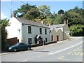
1
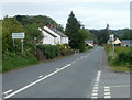
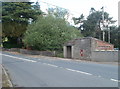
Southern boundary of Llanbadoc
The road north from Llangybi reaches the southern boundary of Llanbadoc, a small village
located on the west bank of the River Usk adjacent to the southern edge of the town of Usk.
The entrance http://www.geograph.org.uk/photo/2917535 to Usk Garden Centre is in the lower right corner of the view.
Image: © Jaggery
Taken: 15 May 2011
0.03 miles
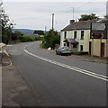
2
Road through Llanbadoc
This road between Caerleon and Usk is an unclassified yet appears very busy with traffic.
Image: © Philip Halling
Taken: 19 Apr 2009
0.04 miles
3
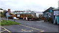
Usk Garden Centre
Business based on a real growing nursery.
Image: © Jonathan Billinger
Taken: 21 Nov 2007
0.05 miles
4
Entrance to Usk Garden Centre, Llanbadoc
Viewed from the Llangybi to Usk road.
Image: © Jaggery
Taken: 15 May 2011
0.09 miles
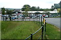
5
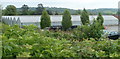
Nursery greenhouses, Usk Garden Centre, Llanbadoc
The nursery is in the NE corner of the garden centre.
Image: © Jaggery
Taken: 15 May 2011
0.10 miles
6
Postbox and bus stop, Llanbadoc
Located alongside the road from Llangybi to Usk, close to the turning for Prescoed.
Image: © Jaggery
Taken: 22 May 2011
0.10 miles
7
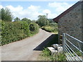
Lane to Lanusk Farm, Llanbadoc
Viewed from the edge of the road from Llangybi to Usk. Just beyond the power lines ahead, the lane turns through 90 degrees to the right (from heading NE to heading SE) on its away to Lanusk Farm on the west bank of the River Usk.
Image: © Jaggery
Taken: 22 May 2011
0.11 miles
8
Road to Prescoed from Llanbadoc
The road to Prescoed and Coed-y-paen heads away from the Llangybi to Usk road, Llanbadoc.
Image: © Jaggery
Taken: 22 May 2011
0.12 miles
9
Llanbadoc houses at Prescoed junction
Viewed along the road from Llangybi to Usk. Ahead, three signs point to the left.
The top one (brown) shows Golf Course 2⅔
The middle one shows
HMP/YOI (Her Majesty's Prison/ Young Offenders' Institution) Prescoed 2
Coed-y-paen 3
Distances are in miles.
The bottom one shows Llandegveth Reservoir (no distance shown).
Image: © Jaggery
Taken: 22 May 2011
0.12 miles
10
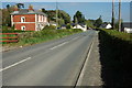
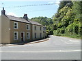
Main road through Llanbadoc
The minor road from Usk towards Llangybi passes through Llanbadoc, a village in Monmouthshire.
Image: © Jaggery
Taken: 30 Aug 2015
0.13 miles