IMAGES TAKEN NEAR TO
Llanbadoc, USK, NP15 1PW
Introduction
This page details the photographs taken nearby to NP15 1PW by members of the Geograph project.
The Geograph project started in 2005 with the aim of publishing, organising and preserving representative images for every square kilometre of Great Britain, Ireland and the Isle of Man.

There are currently over 7.5m images from over14,400 individuals and you can help contribute to the project by visiting https://www.geograph.org.uk
Image Map
Images are licensed for reuse under creativecommons.org/licenses/by-sa/2.0
Notes
- Clicking on the map will re-center to the selected point.
- The higher the marker number, the further away the image location is from the centre of the postcode.
Image Listing (29 Images Found)
Images are licensed for reuse under creativecommons.org/licenses/by-sa/2.0
Image
Details
Distance
1
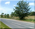
A472 layby, Rhadyr
A narrow, 50 metre long layby is in Rhadyr, NW of the town of Usk.
Image: © Jaggery
Taken: 22 May 2011
0.02 miles
2
Advanced warning in Rhadyr of a low bridge in Little Mill
The sign on the side of the A472 advises that there is a 14' 3" headroom bridge 3 miles ahead.
Image: © Jaggery
Taken: 22 May 2011
0.02 miles

4
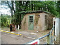
Old works entrance
An obsolete entrance to BAE Systems Glascoed works, the entrance having been reconfigured to 'No Entry' but, at the time of photography in 2007, leaving the public road signs in place.
Image: © Jonathan Billinger
Taken: 21 Nov 2007
0.06 miles
5
BAe Systems Glascoed - disused main entrance
This was the original main entrance to the BAe Land Systems site at Glascoed. The building on the right-hand side was the gatehouse. Although there is a gate and barrier there is actually no sign saying 'No Entry' or 'MOD Property Keep Out'.. The site is not MOD property but is covered by the explosives act and is therefore apparently protected by armed police.
Image: © Nick Mutton 01329 000000
Taken: 2 Sep 2007
0.07 miles
6
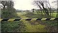
Abandoned gatehouse, Rhadyr
Located at a disused entrance http://www.geograph.org.uk/photo/2998638 to the BAE Systems site.
Image: © Jaggery
Taken: 22 May 2011
0.08 miles
7

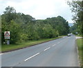
7.5 tonne limit through Usk town
The sign is alongside the A472, between Monkswood and Rhadyr, to the NW of Usk.
Below the main sign are two smaller ones. The yellow one shows that there is CCTV surveillance of Usk Bridge. The blue one tells drivers of heavy vehicles to ignore satnav directions.
Image: © Jaggery
Taken: 22 May 2011
0.08 miles
8
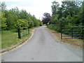
Access road to Rhadyr houses
Viewed from the edge of the A472 near a disused entrance http://www.geograph.org.uk/photo/2998638 to a BAE systems site.
The access road leads to Little Henrhiw and Lisvane.
Image: © Jaggery
Taken: 22 May 2011
0.08 miles
9
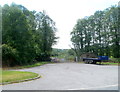
Tree-lined road to an abandoned entrance, Rhadyr
Viewed from the A472. The short connecting road leads to a disused entrance. http://www.geograph.org.uk/photo/2998638
Image: © Jaggery
Taken: 22 May 2011
0.08 miles
10
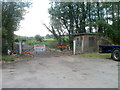
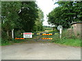
Former Rhadyr entrance to BAE Systems site
A sign on the gate points to the right, informing those wishing to visit the BAE Systems site that the main entrance is a mile and a half away, at RO Defence Glascoed.
Image: © Jaggery
Taken: 22 May 2011
0.08 miles