IMAGES TAKEN NEAR TO
The Meadows, USK, NP15 1BZ
Introduction
This page details the photographs taken nearby to The Meadows, NP15 1BZ by members of the Geograph project.
The Geograph project started in 2005 with the aim of publishing, organising and preserving representative images for every square kilometre of Great Britain, Ireland and the Isle of Man.

There are currently over 7.5m images from over14,400 individuals and you can help contribute to the project by visiting https://www.geograph.org.uk
Image Map (Loading...)


Getting Data...Please wait
Leaflet Map data © OpenStreetMap
Images are licensed for reuse under creativecommons.org/licenses/by-sa/2.0
Notes
- Clicking on the map will re-center to the selected point.
- The higher the marker number, the further away the image location is from the centre of the postcode.
Image Listing (530 Images Found)
Images are licensed for reuse under creativecommons.org/licenses/by-sa/2.0
Image
Details
Distance
1
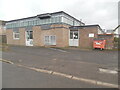
Usk Telephone Exchange
Situated in The Meadows NP15 1BT, this rather unprepossessing TE dates from the late 1960s when several were built as part of the modernisation of the telephone service at that time. It has the code SWUAH and provides telephone and broadband services to approximately 1,634 residential and 216 non-residential premises in Usk, Coed-y-paen, Gwehelog, Gwernesney, Llanbadoc, Llantrisant and the surrounding rural area. The numbering range of this TE is (01291) 67xxxx, the (01291) referring to the Chepstow group of seven TEs.
Image: © David Hillas
Taken: 7 Mar 2023
0.04 miles
2
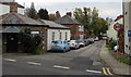
Four Ash Street houses, Usk
Viewed from the southeast end of Castle Street. The Four Ash St(reet) name sign is on railings on the left.
Image: © Jaggery
Taken: 30 Aug 2020
0.04 miles
3

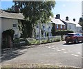
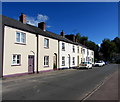
Mediaeval Houses
The houses in Four Ash Street near St Mary's Church once occupied by the Benedictine Priest of Usk Priory until 1530.
Image: © Gordon Griffiths
Taken: 16 Sep 2011
0.05 miles
4
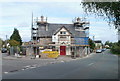
Greyhound Inn, Usk
Scaffolding encases the Greyhound Inn, located on the corner of Black Barn Lane (on the left) and Chepstow Road.
Image: © Jaggery
Taken: 26 Sep 2010
0.05 miles
5
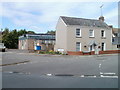
Corner of The Meadows and Black Barn Lane, Usk
Viewed from Chepstow Road. The Meadows (leading to Four Ash Court and Blackfriars) is on the left.
Image: © Jaggery
Taken: 26 Sep 2010
0.05 miles
6
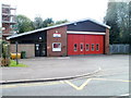
Usk Fire Station and training tower
Located on the south side of Monmouth Road. Scaffolding surrounds the training tower.
Image: © Jaggery
Taken: 26 Sep 2010
0.05 miles
7
One-way Castle Street, Usk
Viewed across the A472 Castle Parade looking along Castle Street towards Four Ash Street.
Grade II listed Ty Basket https://www.geograph.org.uk/photo/6033383 is on the left.
Image: © Jaggery
Taken: 3 Nov 2018
0.06 miles
8

Four houses, Ty Brith Gardens, Usk
Viewed across Four Ash Street.
Image: © Jaggery
Taken: 30 Aug 2020
0.06 miles
9
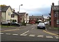
Castle Mews, Usk
Cul-de-sac on the south side of the A472 Monmouth Road.
The bilingual name sign on the left shows that Castle Mews
is Ystablau'r Castell (literally Castle Stables) in Welsh.
Image: © Jaggery
Taken: 3 Nov 2018
0.06 miles
10
Row of houses on the north side of Four Ash Street, Usk
Looking towards the Castle Street junction.
Image: © Jaggery
Taken: 30 Aug 2020
0.06 miles