IMAGES TAKEN NEAR TO
Maryport Street, USK, NP15 1AF
Introduction
This page details the photographs taken nearby to Maryport Street, NP15 1AF by members of the Geograph project.
The Geograph project started in 2005 with the aim of publishing, organising and preserving representative images for every square kilometre of Great Britain, Ireland and the Isle of Man.

There are currently over 7.5m images from over14,400 individuals and you can help contribute to the project by visiting https://www.geograph.org.uk
Image Map
Images are licensed for reuse under creativecommons.org/licenses/by-sa/2.0
Notes
- Clicking on the map will re-center to the selected point.
- The higher the marker number, the further away the image location is from the centre of the postcode.
Image Listing (194 Images Found)
Images are licensed for reuse under creativecommons.org/licenses/by-sa/2.0
Image
Details
Distance
1
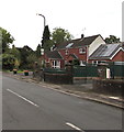
Rooftop solar panels, Maryport Street, Usk
Viewed from the corner of Mill Street in August 2020.
Image: © Jaggery
Taken: 23 Aug 2020
0.00 miles
2
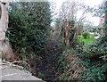
Medieval Black Ditch, Usk
An Usk Civic Society marker http://www.geograph.org.uk/photo/4359966 on the nearby pavement records that the Black Ditch (Clawdd Du in Welsh) was the boundary ditch of the medieval town and a mill stream leading to Usk's third and lowest mill.
Image: © Jaggery
Taken: 14 Dec 2014
0.01 miles
3
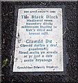
The Black Ditch marker, Usk
The Usk Civic Society marker is on the Maryport Street pavement alongside the Black Ditch. http://www.geograph.org.uk/photo/4359965
Image: © Jaggery
Taken: 14 Dec 2014
0.02 miles
4
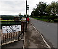
We Say No To One Way System notice, Maryport Street, Usk
Viewed in August 2020. This is one of many dozens (perhaps hundreds) of similar notices throughout Usk objecting to the recently-introduced alternating one-way traffic system https://www.geograph.org.uk/photo/6570918 on the A472 Bridge Street in the centre of Usk. I didn't see any We Say Yes notices.
Image: © Jaggery
Taken: 23 Aug 2020
0.02 miles
5

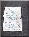
Ancient Roman fort marker at the edge of Usk
The rectangular Usk Civic Society plaque http://www.geograph.org.uk/photo/4359959 on the pavement marks the southern edge of the first Roman fort of the XX legion from 55AD to 65AD.
Image: © Jaggery
Taken: 14 Dec 2014
0.02 miles
6
Ancient Roman fort marker at the edge of Usk
Located here http://www.geograph.org.uk/photo/4359958
Image: © Jaggery
Taken: 14 Dec 2014
0.02 miles
7
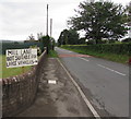
Mill Lane Not Suitable For Large Vehicles, Usk
The arrow on the nonstandard notice alongside Maryport Street
points towards this https://www.geograph.org.uk/photo/6578764 road (shown on maps as Mill Street).
Image: © Jaggery
Taken: 23 Aug 2020
0.02 miles
8
We Say No To One Way System notice on an Usk corner
Viewed in August 2020. This notice on the corner of Maryport Street and Mill Street is one of many dozens (perhaps hundreds) of similar notices throughout Usk objecting to the recently-introduced alternating one-way traffic system https://www.geograph.org.uk/photo/6570918 on the A472 Bridge Street in the centre of Usk. I didn't see any notices stating We Say Yes.
Image: © Jaggery
Taken: 23 Aug 2020
0.03 miles
9
Two notices at the eastern end of Mill Street, Usk
Facing Maryport Street in August 2020. The yellow notice shows CAR BOOT (SALE) BUYERS THIS WAY. Showing WE SAY NO TO ONE WAY SYSTEM, the notice on the right is one of many dozens (perhaps hundreds) of similar notices throughout Usk objecting to the recently-introduced alternating one-way traffic system https://www.geograph.org.uk/photo/6570918 on the A472 Bridge Street in the centre of Usk. I didn't see any notices showing We Say Yes.
Image: © Jaggery
Taken: 23 Aug 2020
0.03 miles
10
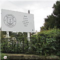
Usk Athletic Club nameboard
Near the corner of Mill Street and Maryport Street in Usk, Monmouthshire in August 2020. Text on the club's badge includes EST(ABLISHED) 1857 and TOGETHER IN SPORT. The right side of the board shows Home of Usk Cricket Club / Usk Tennis Club / Usk Junior Football Club / Usk Netball Club /Usk Runners.
Image: © Jaggery
Taken: 23 Aug 2020
0.03 miles