IMAGES TAKEN NEAR TO
Abertillery Road, ABERTILLERY, NP13 3DZ
Introduction
This page details the photographs taken nearby to Abertillery Road, NP13 3DZ by members of the Geograph project.
The Geograph project started in 2005 with the aim of publishing, organising and preserving representative images for every square kilometre of Great Britain, Ireland and the Isle of Man.

There are currently over 7.5m images from over14,400 individuals and you can help contribute to the project by visiting https://www.geograph.org.uk
Image Map
Images are licensed for reuse under creativecommons.org/licenses/by-sa/2.0
Notes
- Clicking on the map will re-center to the selected point.
- The higher the marker number, the further away the image location is from the centre of the postcode.
Image Listing (30 Images Found)
Images are licensed for reuse under creativecommons.org/licenses/by-sa/2.0
Image
Details
Distance
1
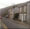
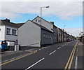
Detached house and two semis, Abertillery Road, Blaina
Looking south along Abertillery Road.
Image: © Jaggery
Taken: 3 Feb 2011
0.02 miles
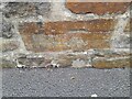
2
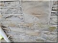
Ordnance Survey Cut Mark
This OS cut mark can be found on No112 Abertillery Road. It marks a point 262.732m above mean sea level.
Image: © Adrian Dust
Taken: 30 Jun 2023
0.03 miles
3
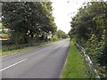
A467 in a former railway route in the south of Blaina
The road here uses the trackbed of a dismantled railway. This view is looking towards the former Bournville (Mon) Halt. Blaina railway station was 750 metres behind the camera. Passenger services on this route ended in 1962.
Image: © Jaggery
Taken: 18 Sep 2013
0.03 miles
4
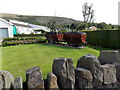
Two former drams in a Blaina garden
Viewed from Abertillery Road. A dram was a truck (on rails) that was used in coal mining.
Image: © Jaggery
Taken: 18 Sep 2013
0.05 miles
5
Ordnance Survey Cut Mark
This OS cut mark can be found on the cemetery wall. It marks a point 259.004m above mean sea level.
Image: © Adrian Dust
Taken: 30 Jun 2023
0.07 miles
6
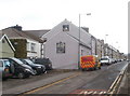
JP Print and Stationery Supplies, Blaina
The AA van is parked alongside the print and stationery premises, Abertillery Road.
Image: © Jaggery
Taken: 3 Feb 2011
0.08 miles
7
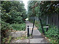
Barrier across a path near Duffryn Park, Blaina
The inward-sloping metal barriers prevent the passage of cars or lorries.
A few tens of metres ahead is the southern entrance to Duffryn Park.
Image: © Jaggery
Taken: 18 Sep 2013
0.08 miles
8
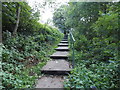
Steps up to the A467 in Blaina
Viewed from the SE corner of Duffryn Park.
Image: © Jaggery
Taken: 18 Sep 2013
0.08 miles
9
JP Print, Blaina
Located at 124 Abertillery Road in Blaina, JP Print specialises in printing, signs and banners.
Image: © Jaggery
Taken: 18 Sep 2013
0.09 miles
10
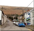
Henwaun Street, Blaina
The photographer is standing on ground elevation 275 metres (about 900 feet) above sea level, looking up Henwaun Street towards a ridge of high ground at about 500 metres (1640 feet) above sea level.
Image: © Jaggery
Taken: 3 Feb 2011
0.09 miles