IMAGES TAKEN NEAR TO
Chapel Square, ABERTILLERY, NP13 3DA
Introduction
This page details the photographs taken nearby to Chapel Square, NP13 3DA by members of the Geograph project.
The Geograph project started in 2005 with the aim of publishing, organising and preserving representative images for every square kilometre of Great Britain, Ireland and the Isle of Man.

There are currently over 7.5m images from over14,400 individuals and you can help contribute to the project by visiting https://www.geograph.org.uk
Image Map
Images are licensed for reuse under creativecommons.org/licenses/by-sa/2.0
Notes
- Clicking on the map will re-center to the selected point.
- The higher the marker number, the further away the image location is from the centre of the postcode.
Image Listing (62 Images Found)
Images are licensed for reuse under creativecommons.org/licenses/by-sa/2.0
Image
Details
Distance
1
Road to Cwmcelyn from High Street Blaina
The road leads to the Cwmcelyn area of Blaina, and Cwmcelyn Pond, a small recreational lake with walks, a picnic area and fishing.
Image: © Jaggery
Taken: 26 Jul 2013
0.02 miles
2
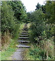
Steps up to a path to Surgery Road, Blaina
Viewed from the road to Cwmcelyn, near Blaina police station. http://www.geograph.org.uk/photo/3574966
Image: © Jaggery
Taken: 18 Sep 2013
0.04 miles
3
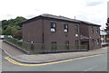
Blaina Police Station
Part of Gwent Police force, the station is on the corner of High Street and the road to Cwmcelyn.
Image: © Jaggery
Taken: 26 Jul 2013
0.04 miles
4
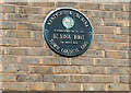
Blaina Riot plaque
The plaque is on the wall here. http://www.geograph.org.uk/photo/3575014 The riot occurred during the prolonged economic depression of the 1930s. Many thousands of unemployed people from Blaina and neighbouring areas marched here, to what were at the time the local Public Assistance Committee offices. The harsh means test in use was hated by the unemployed. The ensuing confrontation between the marchers and police is known as the Blaina Riot or Riots.
Image: © Jaggery
Taken: 26 Jul 2013
0.05 miles
5
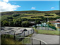
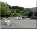
Recreation area in Blaina
Viewed from the road to Cwmcelyn. BMX and skateboard area on the left, multi-use games court on the right.
Image: © Jaggery
Taken: 18 Sep 2013
0.05 miles
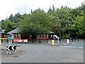
6
Council offices, Blaina
This is Blaenau Gwent County Borough council's Nantyglo & Blaina District Office in High Street Blaina.
A plaque http://www.geograph.org.uk/photo/3575045 on the wall commemorates the Blaina Riots of March 21st 1935.
Image: © Jaggery
Taken: 26 Jul 2013
0.06 miles
7
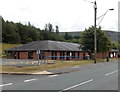
Blaina Community Centre
On the left, Blaenau Gwent Psychology Service occupies part of the High Street community centre.
Image: © Jaggery
Taken: 26 Jul 2013
0.06 miles
8
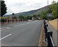
Road from High Street to Station Road, Blaina
An unnamed road heads SSW away from High Street towards Station Road.
Blaina railway station used to be about 500 metres ahead. Passenger services ceased in 1962.
Image: © Jaggery
Taken: 26 Jul 2013
0.06 miles
9
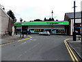
The Co-operative Food store, Blaina
The store is at 53 High Street, Blaina.
Image: © Jaggery
Taken: 26 Jul 2013
0.08 miles
10
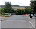
Lockup garages, Blaina
Located in a corner of a car park on the west side of High Street.
Image: © Jaggery
Taken: 26 Jul 2013
0.09 miles