IMAGES TAKEN NEAR TO
Blaina, ABERTILLERY, NP13 3BP
Introduction
This page details the photographs taken nearby to NP13 3BP by members of the Geograph project.
The Geograph project started in 2005 with the aim of publishing, organising and preserving representative images for every square kilometre of Great Britain, Ireland and the Isle of Man.

There are currently over 7.5m images from over14,400 individuals and you can help contribute to the project by visiting https://www.geograph.org.uk
Image Map
Images are licensed for reuse under creativecommons.org/licenses/by-sa/2.0
Notes
- Clicking on the map will re-center to the selected point.
- The higher the marker number, the further away the image location is from the centre of the postcode.
Image Listing (74 Images Found)
Images are licensed for reuse under creativecommons.org/licenses/by-sa/2.0
Image
Details
Distance
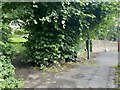
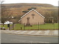
3
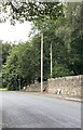
Stone wall boundary to St Peter?s Church
Image: © Alan Hughes
Taken: 9 Aug 2021
0.02 miles
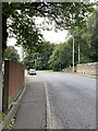
4
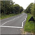
Location of dismantled Blaina railway station
Located in West Side, Blaina, the A467 here follows the route of a dismantled railway. Blaina railway station used to be here. Passenger services in this area ended in 1962. Nearby are Station Road and Railway Terrace.
Image: © Jaggery
Taken: 18 Sep 2013
0.02 miles
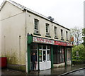
5
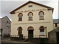
Salem Baptist Chapel, Blaina
Grade II listed building on High Street, opposite the post office. http://www.geograph.org.uk/photo/2257987
The chapel dates from 1848.
Image: © Jaggery
Taken: 3 Feb 2011
0.03 miles
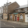
7
Blaina RFC, The Castle, Blaina
Blaina Rugby Football Club's social club is in The Castle, 73 High Street.
Founded in 1875, Blaina RFC play in Welsh Rugby Union Division Three East (season 2010-2011).
Image: © Jaggery
Taken: 3 Feb 2011
0.03 miles
8
St Peter's Church, Blaina
This modern building on the west side of High Street is the fourth St Peter's Church to occupy this location. The first one was built c1500. The second one, built in 1827, was destroyed by fire in 1853. The third one, opened in 1857, was closed down after colliery workings undermined the foundations.
Image: © Jaggery
Taken: 3 Feb 2011
0.03 miles
9
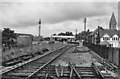
Blaina Station (remains)
View NW, towards Brynmawr; ex-GW Newport - Aberbeeg - Brynmawr line. Station closed, along with passenger service Aberbeeg - Brynmawr 30/4/62, but coal continued to run down the valley until 5/7/76.
Image: © Ben Brooksbank
Taken: 14 Jul 1966
0.04 miles