IMAGES TAKEN NEAR TO
Victoria Street, ABERTILLERY, NP13 3BG
Introduction
This page details the photographs taken nearby to Victoria Street, NP13 3BG by members of the Geograph project.
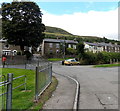
The Geograph project started in 2005 with the aim of publishing, organising and preserving representative images for every square kilometre of Great Britain, Ireland and the Isle of Man.

There are currently over 7.5m images from over14,400 individuals and you can help contribute to the project by visiting https://www.geograph.org.uk
Image Map
Images are licensed for reuse under creativecommons.org/licenses/by-sa/2.0
Notes
- Clicking on the map will re-center to the selected point.
- The higher the marker number, the further away the image location is from the centre of the postcode.
Image Listing (68 Images Found)
Images are licensed for reuse under creativecommons.org/licenses/by-sa/2.0
Image
Details
Distance
1
Victoria Street Blaina
Houses at the northern end of Victoria Street.
Image: © Jaggery
Taken: 18 Sep 2013
0.00 miles
2
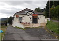
Indian Valley, Blaina
Bar and Indian cuisine restaurant in West Side, along a lane south of Chapel Road.
Image: © Jaggery
Taken: 18 Sep 2013
0.03 miles
3
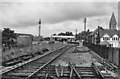
Blaina Station (remains)
View NW, towards Brynmawr; ex-GW Newport - Aberbeeg - Brynmawr line. Station closed, along with passenger service Aberbeeg - Brynmawr 30/4/62, but coal continued to run down the valley until 5/7/76.
Image: © Ben Brooksbank
Taken: 14 Jul 1966
0.05 miles
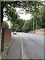
4
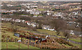
Terraced housing of West View
West View is part of Blaina; the terrace in view is Glen (or Glan) Ebbw. The view is from the rising hill slope on the west side of the valley in which the town lies.
Image: © Trevor Littlewood
Taken: 6 Mar 2008
0.06 miles
5
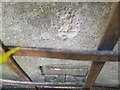
Ordnance Survey Cut Mark
This OS cut mark can be found on the garage east side of the road. It marks a point 284.516m above mean sea level.
Image: © Adrian Dust
Taken: 30 Jun 2023
0.07 miles
6
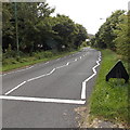
Location of dismantled Blaina railway station
Located in West Side, Blaina, the A467 here follows the route of a dismantled railway. Blaina railway station used to be here. Passenger services in this area ended in 1962. Nearby are Station Road and Railway Terrace.
Image: © Jaggery
Taken: 18 Sep 2013
0.07 miles
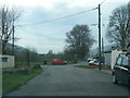
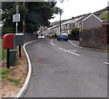
10
West Side, Blaina
Looking towards The Yew Tree http://www.geograph.org.uk/photo/3662024 which is the white building in the background.
Turn left near the red postbox for Victoria Street. http://www.geograph.org.uk/photo/3662026
Image: © Jaggery
Taken: 18 Sep 2013
0.09 miles