IMAGES TAKEN NEAR TO
The Walk, ABERTILLERY, NP13 3AL
Introduction
This page details the photographs taken nearby to The Walk, NP13 3AL by members of the Geograph project.
The Geograph project started in 2005 with the aim of publishing, organising and preserving representative images for every square kilometre of Great Britain, Ireland and the Isle of Man.

There are currently over 7.5m images from over14,400 individuals and you can help contribute to the project by visiting https://www.geograph.org.uk
Image Map
Images are licensed for reuse under creativecommons.org/licenses/by-sa/2.0
Notes
- Clicking on the map will re-center to the selected point.
- The higher the marker number, the further away the image location is from the centre of the postcode.
Image Listing (34 Images Found)
Images are licensed for reuse under creativecommons.org/licenses/by-sa/2.0
Image
Details
Distance
1
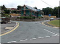
New house being built on the corner of The Walk and Park View, Blaina
Viewed across Surgery Road in late July 2013.
Image: © Jaggery
Taken: 26 Jul 2013
0.03 miles
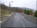
2
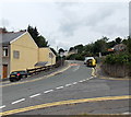
The Walk, Blaina
The Walk climbs away from the corner of Park View. There is a 20mph speed limit ahead on the approach to Coed y Garn Primary School, Nantyglo.
Image: © Jaggery
Taken: 26 Jul 2013
0.04 miles
3
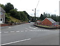
Surgery Road, Nantyglo and Blaina
Surgery Road heads into Blaina away from High Street in Nantyglo.
Image: © Jaggery
Taken: 26 Jul 2013
0.07 miles
4
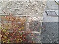
Ordnance Survey Cut Mark
This OS cut mark can be found on No11 Surgery Road. It marks a point 327.748m above mean sea level.
Image: © Adrian Dust
Taken: 30 Jun 2023
0.07 miles
5
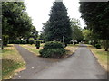
Fork in the path, Central Park, Blaina
At the northern edge of the park, near the entrance http://www.geograph.org.uk/photo/3572871 from Surgery Road.
Image: © Jaggery
Taken: 26 Jul 2013
0.08 miles
6
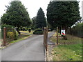
Northern entrance to Central Park, Blaina
This entrance is from Surgery Road at the northern edge of the park. There is a large sports field in the south of the park.
Image: © Jaggery
Taken: 26 Jul 2013
0.08 miles
7
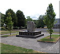
Nantyglo and Blaina War Memorial in Central Park, Blaina
The War Memorial is dedicated "to the glory of God and in memory of the men and women of Nantyglo and Blaina who gave their lives in the service of our country".
Image: © Jaggery
Taken: 26 Jul 2013
0.09 miles
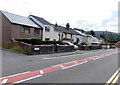
8
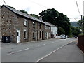
Surgery Road houses, Blaina
The houses face Central Park.
Image: © Jaggery
Taken: 26 Jul 2013
0.09 miles
10
Row of houses, High Street, Nantyglo
The houses are between Parrot Row http://www.geograph.org.uk/photo/3571882 behind the camera and Surgery Road ahead.
This is the southern edge of Nantyglo. The northern boundary of Blaina is near Surgery Road.
Image: © Jaggery
Taken: 26 Jul 2013
0.10 miles