IMAGES TAKEN NEAR TO
Vivian Street, ABERTILLERY, NP13 2LD
Introduction
This page details the photographs taken nearby to Vivian Street, NP13 2LD by members of the Geograph project.
The Geograph project started in 2005 with the aim of publishing, organising and preserving representative images for every square kilometre of Great Britain, Ireland and the Isle of Man.

There are currently over 7.5m images from over14,400 individuals and you can help contribute to the project by visiting https://www.geograph.org.uk
Image Map
Images are licensed for reuse under creativecommons.org/licenses/by-sa/2.0
Notes
- Clicking on the map will re-center to the selected point.
- The higher the marker number, the further away the image location is from the centre of the postcode.
Image Listing (162 Images Found)
Images are licensed for reuse under creativecommons.org/licenses/by-sa/2.0
Image
Details
Distance
1
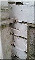
Ordnance Survey Cut Mark
This OS cut mark can be found on No131 Somerset Street. It marks a point 225.208m above mean sea level.
Image: © Adrian Dust
Taken: 20 Jan 2018
0.03 miles
2
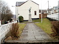
Abertillery War Memorial
Located between Somerset Street and Queen Street, opposite the TA Centre. http://www.geograph.org.uk/photo/2293008
The memorial was unveiled by Field Marshal Allenby (1st Viscount Allenby) in 1926.
It is dedicated to "the memory of the MEN of ABERTILLERY who made the supreme sacrifice in THE GREAT WAR 1914 - 1918."
Image: © Jaggery
Taken: 16 Feb 2011
0.04 miles
3
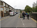
Castle Street
Cerddwyr yn gwyro oddi ar Stryd y Castell at lwybr beicio.
Walkers leaving Castle Street by following a cycle track.
Image: © Alan Richards
Taken: 12 Oct 2014
0.04 miles
4
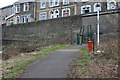
Ebbw Fach Trail at Lower Castle Street
The trail, part of National Cycle Route 465, goes up on to the street and then turns left. The houses behind are on Castle Street.
Image: © M J Roscoe
Taken: 20 Mar 2019
0.04 miles
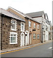
5
Somerset Street houses near Abertillery police station
The police station http://www.geograph.org.uk/photo/2293054 is immediately to the left of the house on the left.
Image: © Jaggery
Taken: 5 Mar 2014
0.04 miles
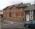
6
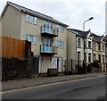
Recently-built flats in Somerset Street Abertillery
The flats on the left were built in 2009-2010.
Image: © Jaggery
Taken: 5 Mar 2014
0.05 miles
7
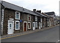
Somerset Street, Abertillery
Houses on the north side of the street, near the War Memorial. http://www.geograph.org.uk/photo/2293031
Image: © Jaggery
Taken: 16 Feb 2011
0.05 miles
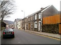
8
Ex Home Guard Officers Club, Abertillery
The building in the middle, with a black Carling sign projecting from the wall, is the Ex Home Guard Officers Club at 109 Somerset Street.
Image: © Jaggery
Taken: 16 Feb 2011
0.05 miles
9
Abertillery Police Station
Part of Gwent Police, the station is at 85-95 Somerset Street.
Image: © Jaggery
Taken: 16 Feb 2011
0.05 miles
10
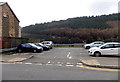
Small car park, Somerset Street, Abertillery
Near the police station. http://www.geograph.org.uk/photo/2293054
Image: © Jaggery
Taken: 5 Mar 2014
0.05 miles