IMAGES TAKEN NEAR TO
Trinant Hall Lane, ABERTILLERY, NP13 2JR
Introduction
This page details the photographs taken nearby to Trinant Hall Lane, NP13 2JR by members of the Geograph project.
The Geograph project started in 2005 with the aim of publishing, organising and preserving representative images for every square kilometre of Great Britain, Ireland and the Isle of Man.

There are currently over 7.5m images from over14,400 individuals and you can help contribute to the project by visiting https://www.geograph.org.uk
Image Map
Images are licensed for reuse under creativecommons.org/licenses/by-sa/2.0
Notes
- Clicking on the map will re-center to the selected point.
- The higher the marker number, the further away the image location is from the centre of the postcode.
Image Listing (18 Images Found)
Images are licensed for reuse under creativecommons.org/licenses/by-sa/2.0
Image
Details
Distance
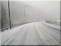
1
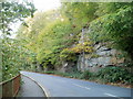
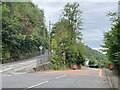
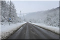
Cliff alongside B4471 south of High Street, Llanhilleth
Partly covered with vegetation, the cliff is on the east side of the B4471, on the approach to High Street, Llanhilleth
Image: © Jaggery
Taken: 6 Oct 2011
0.10 miles
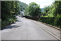
2
Junction of B4471 and Crumlin Road south of Llanhilleth
At the end of a long descent from Sofrydd, the B4471 is joined by Crumlin Road from the left.
Image: © Jaggery
Taken: 6 Oct 2011
0.12 miles
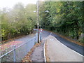
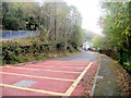
3
Crumlin Road, Llanhilleth
No through road off the B4471 to the south of Llanhilleth.
Image: © Philip Halling
Taken: 10 Aug 2012
0.13 miles
4
Road closed
The old Crumlin Road is now closed. Traffic wanting to join the A467 must now bear left at this junction and get diverted along the B4471 through Swffryd.
Image: © Alan Hughes
Taken: 13 Aug 2024
0.13 miles
5
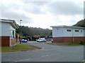
Llanhilleth Industrial Estate
The estate is in the SE corner of Llanhilleth, near a junction with the A467.
Image: © Jaggery
Taken: 6 Oct 2011
0.14 miles
6
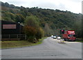
A467 passes edge of Llanhilleth Industrial Estate
The industrial estate is in the SE corner of Llanhilleth. The route of the A467 hereabouts is along the valley of the Ebbw River.
Image: © Jaggery
Taken: 6 Oct 2011
0.16 miles
7
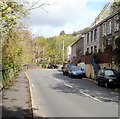
Isolated group of houses at the southern end of High Street, Llanhilleth
The houses on the east side of the B4471, here named High Street, are about 250 metres from the main part of High Street, ahead.
Image: © Jaggery
Taken: 6 Oct 2011
0.16 miles
9
Crumlin Road south of Llanhilleth
Despite its name, this is no longer http://www.geograph.org.uk/photo/2635541 a through road to Crumlin for motor vehicles.
The grey railings on the left are at the edge of the B4471 at the start of its long ascent to Sofrydd.
Image: © Jaggery
Taken: 6 Oct 2011
0.18 miles