IMAGES TAKEN NEAR TO
Brynhyfryd Terrace, ABERTILLERY, NP13 2HL
Introduction
This page details the photographs taken nearby to Brynhyfryd Terrace, NP13 2HL by members of the Geograph project.
The Geograph project started in 2005 with the aim of publishing, organising and preserving representative images for every square kilometre of Great Britain, Ireland and the Isle of Man.

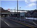
There are currently over 7.5m images from over14,400 individuals and you can help contribute to the project by visiting https://www.geograph.org.uk
Image Map
Images are licensed for reuse under creativecommons.org/licenses/by-sa/2.0
Notes
- Clicking on the map will re-center to the selected point.
- The higher the marker number, the further away the image location is from the centre of the postcode.
Image Listing (182 Images Found)
Images are licensed for reuse under creativecommons.org/licenses/by-sa/2.0
Image
Details
Distance
1
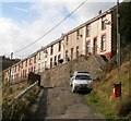
Lower Court Terrace, Llanhilleth
A view NE along Lower Court Terrace from the northern end of Springfield Terrace.
Image: © Jaggery
Taken: 6 Oct 2011
0.09 miles
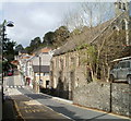
2
Hafodarthen Road, Llanhilleth
The steps on the left (leading up to Victoria Terrace) mark the end of Lower Court Terrace behind the camera, and the start of Hafodarthen Road ahead.
Image: © Jaggery
Taken: 6 Oct 2011
0.09 miles
3
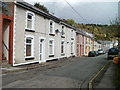
Victoria Terrace, Llanhilleth
Viewed from the edge of Hafodarthen Road.
Image: © Jaggery
Taken: 6 Oct 2011
0.09 miles
4
Llanhilleth post office
Currently (October 2011) located inside a Premier store on Commercial Road.
The previous post office, now vacant, is next door. http://www.geograph.org.uk/photo/2637011
The Premier store was previously a Londis.
Image: © Jaggery
Taken: 6 Oct 2011
0.10 miles
5
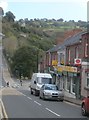
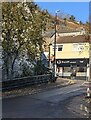
From High Street to Commercial Road, Llanhilleth
The zebra crossing is about the point at which High Street on the camera side becomes Commercial Road in the distance. On the right is St Mark's Church. http://www.geograph.org.uk/photo/2637248
Image: © Jaggery
Taken: 6 Oct 2011
0.10 miles
6
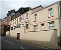
Llanhilleth Conservative & Unionist Club
Located at 20 Commercial Road, Llanhilleth.
Image: © Jaggery
Taken: 6 Oct 2011
0.10 miles
7
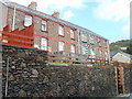
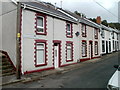
Commercial Road houses, Llanhilleth
These houses, immediately west of the Conservative Club, http://www.geograph.org.uk/photo/2825476 are based a couple of metres above street level.
Image: © Jaggery
Taken: 6 Oct 2011
0.11 miles
8
A1 Salon, Llanhilleth
Commercial Road hair & beauty salon.
Image: © Jaggery
Taken: 8 Dec 2022
0.12 miles
9
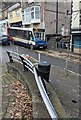
X15 bus, Commercial Road, Llanhilleth
Stagecoach bus 47533 is on Route X15 from Brynmawr to Newport in January 2023.
Image: © Jaggery
Taken: 25 Jan 2023
0.12 miles