IMAGES TAKEN NEAR TO
Brewery Row, ABERTILLERY, NP13 2EL
Introduction
This page details the photographs taken nearby to Brewery Row, NP13 2EL by members of the Geograph project.
The Geograph project started in 2005 with the aim of publishing, organising and preserving representative images for every square kilometre of Great Britain, Ireland and the Isle of Man.

There are currently over 7.5m images from over14,400 individuals and you can help contribute to the project by visiting https://www.geograph.org.uk
Image Map
Images are licensed for reuse under creativecommons.org/licenses/by-sa/2.0
Notes
- Clicking on the map will re-center to the selected point.
- The higher the marker number, the further away the image location is from the centre of the postcode.
Image Listing (108 Images Found)
Images are licensed for reuse under creativecommons.org/licenses/by-sa/2.0
Image
Details
Distance
1
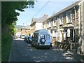
Woodland Terrace, Aberbeeg
Woodland Terrace is aligned SW-NE between the A467 Aberbeeg Road and the Ebbw Fach river. Most alignments is this hilly area are determined by the course of river valleys.
This view is from the SW end.
Image: © Jaggery
Taken: 23 Jun 2010
0.01 miles
2
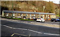
Brewery Terrace, Aberbeeg
Viewed across the B4471. Extending for 40 metres (about 130 ft), the row was built opposite Webbs Brewery, which no longer exists. The brewery, dating from 1838, closed in 1969.
Image: © Jaggery
Taken: 9 Dec 2016
0.01 miles
3
Woodland Terrace, Aberbeeg
On the north side of the B4471.
Image: © Jaggery
Taken: 9 Dec 2016
0.02 miles
4
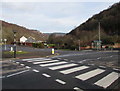
Zebra crossing towards Woodland Terrace, Aberbeeg
Across the B4471. Woodland Terrace is behind the crossing and the bus shelter.
Image: © Jaggery
Taken: 9 Dec 2016
0.02 miles
5
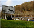
Directions sign facing the B4471 in Aberbeeg
On the approach to the roundabout at the junction with the A467 and A4046. The junction, 100 metres behind the sign, is at the northern end of the B4471, which extends for 5 km from Hafodyrynys.
Image: © Jaggery
Taken: 9 Dec 2016
0.03 miles
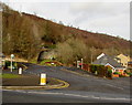
6
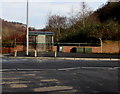
Bus stop and green shelter on an Aberbeeg corner
On the corner of the B4471 and Woodland Terrace. Also in view are a green litter bin and two green flower tubs.
Image: © Jaggery
Taken: 9 Dec 2016
0.03 miles
7
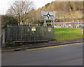
Aberbeeg Kiosk electricity substation, Aberbeeg
The Western Power Distribution electricity substation is inside a fenced enclosure 15 metres south of the B4471.
Its identifier is ABERBEEG KIOSK S/S 552338.
Image: © Jaggery
Taken: 9 Dec 2016
0.03 miles
8
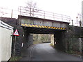
Low railway bridge in Aberbeeg
The sign facing the B4471 junction 30 metres behind the camera shows 10' 9" headroom.
The Network Rail identifier on the bridge is BRIDGE EBW 1430.5 Ebbw Vale Road.
Image: © Jaggery
Taken: 9 Dec 2016
0.04 miles
9
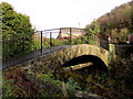
Grade II listed 17th century stone arched bridge, Aberbeeg
The first record of this bridge over the Ebbw Fach River (Afon Ebwy Fach in Welsh) was in 1659.
The metal handrails and fencing and the large metal pipe under the bridge are modern additions.
The bridge was Grade II listed in 2005.
Image: © Jaggery
Taken: 9 Dec 2016
0.05 miles
10
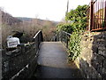
West across a 17th century stone arched bridge, Aberbeeg
http://www.geograph.org.uk/photo/5222071 to a side view of the Grade II listed bridge and a few details.
Image: © Jaggery
Taken: 9 Dec 2016
0.05 miles