IMAGES TAKEN NEAR TO
Windsor Terrace, ABERTILLERY, NP13 2DE
Introduction
This page details the photographs taken nearby to Windsor Terrace, NP13 2DE by members of the Geograph project.
The Geograph project started in 2005 with the aim of publishing, organising and preserving representative images for every square kilometre of Great Britain, Ireland and the Isle of Man.

There are currently over 7.5m images from over14,400 individuals and you can help contribute to the project by visiting https://www.geograph.org.uk
Image Map
Images are licensed for reuse under creativecommons.org/licenses/by-sa/2.0
Notes
- Clicking on the map will re-center to the selected point.
- The higher the marker number, the further away the image location is from the centre of the postcode.
Image Listing (52 Images Found)
Images are licensed for reuse under creativecommons.org/licenses/by-sa/2.0
Image
Details
Distance
1
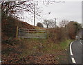
7-bar gate at a field entrance, Cwm Nant Gwynt
Leading to this http://www.geograph.org.uk/photo/5220698 field.
Image: © Jaggery
Taken: 9 Dec 2016
0.10 miles
3
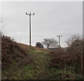
Wires over a Cwm Nant Gwynt field
Viewed from this http://www.geograph.org.uk/photo/5220701 gate.
Image: © Jaggery
Taken: 9 Dec 2016
0.12 miles
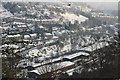
5
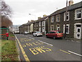
Bute Place houses and bus stop, Cwm Nant Gwynt
Here 260 metres (about 850 ft) above mean sea level, the road descends towards Aberbeeg.
Image: © Jaggery
Taken: 9 Dec 2016
0.14 miles
6
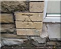
Ordnance Survey Cut Mark
This OS cut mark can be found on No1 Bute Place. It marks a point 257.757m above mean sea level.
Image: © Adrian Dust
Taken: 20 Jul 2019
0.14 miles
7
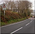
Warning sign - No footway for ? mile, Cwm Nant Gwynt
The bilingual (English/Welsh) sign is alongside the road descending to Aberbeeg from the hamlet of Cwm Nant Gwynt.
Image: © Jaggery
Taken: 9 Dec 2016
0.15 miles
8
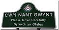
Cwm Nant Gwynt boundary sign detail
Located here. http://www.geograph.org.uk/photo/5220622 I began my walk today in Aberbeeg in the county borough of Blaenau Gwent.
I did not see any boundary signs on the way, but this Cwm Nant Gwynt sign depicts the Caerphilly County Borough crest.
The ermine shield with blue invected chevron symbolises the natural beauty of the area.
The castle represents Caerphilly castle, one of the largest in Europe.
The Welsh red dragon holds a Celtic wheel cross, symbolising the long history of Christianity in the area.
Caerphilly's motto is "Working together for the good of all"
Image: © Jaggery
Taken: 9 Dec 2016
0.15 miles
9
Northern boundary of Cwm Nant Gwynt
The road ascending from Aberbeeg reaches the hamlet of Cwm Nant Gwynt in Caerphilly County Borough.
The Welsh Cwm Nant Gwynt is literally the valley of the brook named Gwynt. Nant Gwynt is a nearby small tributary of the River Ebbw. http://www.geograph.org.uk/photo/5220627 to a closer view of the sign.
Image: © Jaggery
Taken: 9 Dec 2016
0.15 miles
10
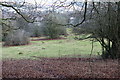
Rough pasture below Pen-y-fan-fach
Pasture with bushes and a few anthills on the hillside above the Christchurch area of Aberbeeg. This field is part of the Pen-y-Fan-Fach Grasslands Site of Importance for Nature Conservation.
Image: © M J Roscoe
Taken: 16 Dec 2016
0.16 miles