IMAGES TAKEN NEAR TO
The Oaks, ABERTILLERY, NP13 2BS
Introduction
This page details the photographs taken nearby to The Oaks, NP13 2BS by members of the Geograph project.
The Geograph project started in 2005 with the aim of publishing, organising and preserving representative images for every square kilometre of Great Britain, Ireland and the Isle of Man.

There are currently over 7.5m images from over14,400 individuals and you can help contribute to the project by visiting https://www.geograph.org.uk
Image Map
Images are licensed for reuse under creativecommons.org/licenses/by-sa/2.0
Notes
- Clicking on the map will re-center to the selected point.
- The higher the marker number, the further away the image location is from the centre of the postcode.
Image Listing (121 Images Found)
Images are licensed for reuse under creativecommons.org/licenses/by-sa/2.0
Image
Details
Distance
1
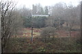
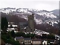
Christ Church, Aberbeeg
Viewed through rain, across the river and A487, from near Railway Terrace. The church, in a state of disrepair, was declared redundant in 2012. Taken on the morning of Storm Gertrude.
Image: © M J Roscoe
Taken: 29 Jan 2016
0.01 miles
3
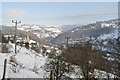
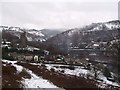
Aberbeeg and Pant-du
The centre of the picture is Aberbeeg church, with the hospital to its right on the hill, all surrounding the hamlet of Pant-du. The river is the combined flow of the Ebwy, the Fach having recently jointed the Fawr.
Image: © Graham Horn
Taken: 3 Feb 2008
0.04 miles
5
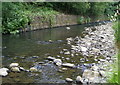
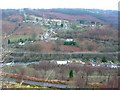
Ebbw River, near Railway Terrace, Aberbeeg, Summer
Looking upstream from behind Aberbeeg RFC Clubhouse; river viewed from a different angle to downstream view in Image
Image: © M J Roscoe
Taken: 25 Jun 2010
0.05 miles
6
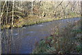
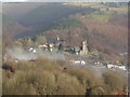
Ebbw River, near Railway Terrace, Aberbeeg, Winter
Looking upstream from almost the same position on the east bank as in Image
Image: © M J Roscoe
Taken: 25 Nov 2011
0.05 miles

10
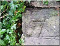
Ordnance Survey Cut Mark
This OS cut mark can be found on the wall at the entrance to Christ Church. It marks a point 200.869m above mean sea level.
Image: © Adrian Dust
Taken: 20 Jul 2019
0.06 miles