IMAGES TAKEN NEAR TO
Aberbeeg, ABERTILLERY, NP13 2AY
Introduction
This page details the photographs taken nearby to NP13 2AY by members of the Geograph project.
The Geograph project started in 2005 with the aim of publishing, organising and preserving representative images for every square kilometre of Great Britain, Ireland and the Isle of Man.

There are currently over 7.5m images from over14,400 individuals and you can help contribute to the project by visiting https://www.geograph.org.uk
Image Map
Images are licensed for reuse under creativecommons.org/licenses/by-sa/2.0
Notes
- Clicking on the map will re-center to the selected point.
- The higher the marker number, the further away the image location is from the centre of the postcode.
Image Listing (52 Images Found)
Images are licensed for reuse under creativecommons.org/licenses/by-sa/2.0
Image
Details
Distance
1
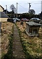
Churchyard exit path, Aberbeeg
From St Illtyd's churchyard.
Image: © Jaggery
Taken: 12 Feb 2023
0.01 miles
2
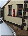
Edwardian postbox, St Illtyd, Aberbeeg
In the wall of the house which used to be the Carpenters Arms.
ER VII on the box indicates the reign of King Edward VII (1901 - 1910).
https://www.geograph.org.uk/photo/7404640 to a closer view.
Image: © Jaggery
Taken: 12 Feb 2023
0.01 miles
3
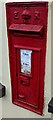
Edwardian postbox detail, St Illtyd, Aberbeeg
The box is located on the wall here. https://www.geograph.org.uk/photo/7404628
Image: © Jaggery
Taken: 12 Feb 2023
0.01 miles
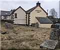
4
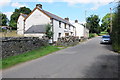
Carpenters Arms, St Illtyd
The Carpenters Arms is situated next to St Illtyd church.
Image: © Philip Halling
Taken: 10 Aug 2012
0.02 miles
5
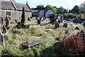
Churchyard, St Illtyd
The southeast part of the graveyard just before the summer's growth was cut and removed by a Gwent Wildlife Trust working party to promote the growth of wild flowers. The Carpenters Arms in the background adjoins the churchyard. The deconsecrated church is grade II* listed.
Image: © M J Roscoe
Taken: 19 Sep 2017
0.02 miles
6
Carpenters Arms name, Aberbeeg, Blaenau Gwent
Viewed from St Illtyd's churchyard in February 2023. The name
of the former pub remains on the wall of what is now a large house.
Image: © Jaggery
Taken: 12 Feb 2023
0.02 miles
7
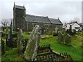
St. Illtyd's church
Now deconsecrated this church has been restored using EC and CADW funds. To the right is The Carpenter's Arms, the classic village setting of pub next to the church.
Image: © Graham Horn
Taken: 3 Feb 2008
0.02 miles
8
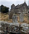
Headstones and church, Aberbeeg
Looking over a stone wall towards St Illtyd's church in
a remote location about 360 metres (c 1,180ft) above sea level.
Image: © Jaggery
Taken: 12 Feb 2023
0.03 miles
9
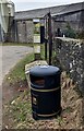
Two bins, Aberbeeg
A litter bin and a salt / grit bin are alongside a perimeter wall of St Illtyd's churchyard.
Image: © Jaggery
Taken: 12 Feb 2023
0.03 miles
10
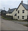
St Illtyd houses, Aberbeeg, Blaenau Gwent
Opposite St Illtyd's churchyard.
Image: © Jaggery
Taken: 12 Feb 2023
0.03 miles