IMAGES TAKEN NEAR TO
Castle Street, ABERTILLERY, NP13 1UR
Introduction
This page details the photographs taken nearby to Castle Street, NP13 1UR by members of the Geograph project.
The Geograph project started in 2005 with the aim of publishing, organising and preserving representative images for every square kilometre of Great Britain, Ireland and the Isle of Man.

There are currently over 7.5m images from over14,400 individuals and you can help contribute to the project by visiting https://www.geograph.org.uk
Image Map
Images are licensed for reuse under creativecommons.org/licenses/by-sa/2.0
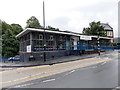
Notes
- Clicking on the map will re-center to the selected point.
- The higher the marker number, the further away the image location is from the centre of the postcode.
Image Listing (148 Images Found)
Images are licensed for reuse under creativecommons.org/licenses/by-sa/2.0
Image
Details
Distance
4
Passing Through Abertillery
Class 33, 33019 heads the Welsh Washery Wanderer through Abertillery. On the right are the houses on Carlyle Street and an industrial building that has been demolished. In the centre are some more houses on Glan Ebbw Terrace. In the distance the A467 and a powerline route cross the lower slopes of Cefn Bach.
Image: © Martin Addison
Taken: 28 Sep 1985
0.03 miles
5
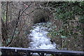
Nant Tillery, Abertillery
Looking upstream at an open section of the stream before it again disappears into a culvert under Glan Ebbw Terrace (camera position).
Image: © M J Roscoe
Taken: 26 Dec 2018
0.04 miles
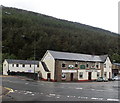
6
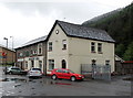
The Railway Inn viewed from the north, Abertillery
The pub is on the corner of Bridge Street and Aberbeeg Road. The rear of the pub is at the edge of a river, the Ebbw Fach.
Image: © Jaggery
Taken: 14 Jun 2013
0.04 miles
7
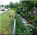
The river that gave the town its name, Abertillery
The Tillery (Afon Tyleri in Welsh) flows towards its confluence with the Ebbw Fach a few tens of metres behind the camera. That point, the mouth (aber in Welsh) of the river, is the derivation of the town's name.
Image: © Jaggery
Taken: 14 Jun 2013
0.05 miles
8
A glimpse into Abertillery library
This is the southern side of the library, viewed from Castle Street.
Image: © Jaggery
Taken: 14 Jun 2013
0.05 miles
9
Abertillery Library
This is the Castle Street side of the library on the corner of Station Hill.
It is part of the Blaenau Gwent County Borough Council library service.
Image: © Jaggery
Taken: 14 Jun 2013
0.05 miles
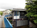
10
The Railway Inn, Abertillery
Pub on the corner of Bridge Street and Aberbeeg Road.
Image: © Jaggery
Taken: 14 Jun 2013
0.05 miles