IMAGES TAKEN NEAR TO
Station Hill, ABERTILLERY, NP13 1UJ
Introduction
This page details the photographs taken nearby to Station Hill, NP13 1UJ by members of the Geograph project.
The Geograph project started in 2005 with the aim of publishing, organising and preserving representative images for every square kilometre of Great Britain, Ireland and the Isle of Man.

There are currently over 7.5m images from over14,400 individuals and you can help contribute to the project by visiting https://www.geograph.org.uk
Image Map
Images are licensed for reuse under creativecommons.org/licenses/by-sa/2.0
Notes
- Clicking on the map will re-center to the selected point.
- The higher the marker number, the further away the image location is from the centre of the postcode.
Image Listing (166 Images Found)
Images are licensed for reuse under creativecommons.org/licenses/by-sa/2.0
Image
Details
Distance
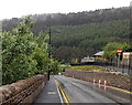
1
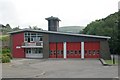
Abertillery Fire Station
Abertillery Fire Station, Station Hill, Abertillery is part of South Wales Fire & Rescue Service
Image: © Kevin Hale
Taken: 4 Jun 2007
0.00 miles
2
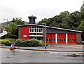
Abertillery Fire Station
The fire station was opened in 1966, built on the site of old railway sidings located between Alma Street, Station Hill and Castle Street. Part of South Wales Fire & Rescue Service, the station serves the town of Abertillery and the villages of Cwmtillery, Llanhilleth, Aberbeeg, Trinant and Six Bells.
Image: © Jaggery
Taken: 14 Jun 2013
0.01 miles
3
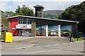
Abertillery Emergency Services Station
The former fire station now houses the three emergency services. Each has its own vehicle bay, hence the pictures on the doors.
Image: © M J Roscoe
Taken: 31 Aug 2018
0.01 miles
4
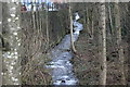
Nant Tillery by Station Hill
At the top of the picture the stream has just emerged from a long culvert.
Image: © M J Roscoe
Taken: 16 Feb 2018
0.01 miles
5
Alma Street, Abertillery
Alma Street descends from the corner of Gladstone Street towards Castle Street.
Wisps of clouds can be seen near the top of the distant woodland.
Image: © Jaggery
Taken: 14 Jun 2013
0.02 miles
6
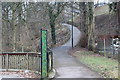
Green Walk
Path from behind library up to Church Street; St Michael's Church can just be discerned through the trees at the top of the picture. The Nant Tillery Image is at the bottom of the wooded hill, left, just out of shot.
Image: © M J Roscoe
Taken: 22 Feb 2018
0.03 miles
7
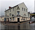
The Penndragon, Abertillery
Pub on the corner of Oak Street and Alma Street. A sign above the door on the left states that The Penndragon is the home of Abertillery RFC (Rugby Football Club).
Pendragon is English for an ancient British supreme chief. I don't know the reason for the double n in the name of this pub.
Image: © Jaggery
Taken: 14 Jun 2013
0.04 miles
8
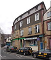
Taxis and Diana's Unisex Salon in Abertillery
Viewed across High Street.
Image: © Jaggery
Taken: 5 Mar 2014
0.05 miles
9
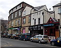
S.M.Ash shop and a row of taxis in Abertillery
Viewed across High Street. Looking at first glance like SMASH, the white name on the black board is S.M.ASH, cycle sales, spares & repairs, keys cut, shoe repairs, sports goods, fishing tackle, airguns, etc.
Marenghi's Cafe is on the right.
Image: © Jaggery
Taken: 5 Mar 2014
0.05 miles
10
A glimpse into Abertillery library
This is the southern side of the library, viewed from Castle Street.
Image: © Jaggery
Taken: 14 Jun 2013
0.05 miles