IMAGES TAKEN NEAR TO
Morley Road, ABERTILLERY, NP13 1TP
Introduction
This page details the photographs taken nearby to Morley Road, NP13 1TP by members of the Geograph project.
The Geograph project started in 2005 with the aim of publishing, organising and preserving representative images for every square kilometre of Great Britain, Ireland and the Isle of Man.

There are currently over 7.5m images from over14,400 individuals and you can help contribute to the project by visiting https://www.geograph.org.uk
Image Map
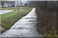
Images are licensed for reuse under creativecommons.org/licenses/by-sa/2.0
Notes
- Clicking on the map will re-center to the selected point.
- The higher the marker number, the further away the image location is from the centre of the postcode.
Image Listing (24 Images Found)
Images are licensed for reuse under creativecommons.org/licenses/by-sa/2.0
Image
Details
Distance
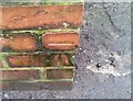
1
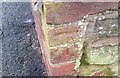
Ordnance Survey Cut Mark
This OS cut mark can be found on the garage SW side of the road. It marks a point 249.924m above mean sea level.
Image: © Adrian Dust
Taken: 20 Jan 2018
0.08 miles
2
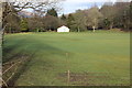
Cricket ground in winter, Abertillery Park
Grass recovering before the season starts.
Image: © M J Roscoe
Taken: 16 Feb 2018
0.09 miles
3
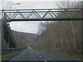
A467 northbound near Abertillery cricket ground
Image: © Colin Pyle
Taken: 4 Jan 2018
0.10 miles
4
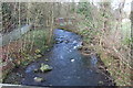
River Ebbw Fach by cricket ground, Abertillery Park
Looking upstream from a footbridge; National Cycle Route 465 is on the left of the railings. Fifty years ago the river was black with coal waste and called the 'River Stink' by the locals.
Image: © M J Roscoe
Taken: 16 Feb 2018
0.11 miles
5
River Ebbw Fach by car park, Abertillery Park
Looking downstream from same footbridge as in Image The houses on the left are on Glandwr Street; the semi-detached houses (top left) facing the camera are Park Villas Image
Image: © M J Roscoe
Taken: 16 Feb 2018
0.11 miles
6
Ordnance Survey Cut Mark
This OS cut mark can be found on the garage SW side of Rose Heyworth Road. It marks a point 249.494m above mean sea level.
Image: © Adrian Dust
Taken: 20 Jan 2018
0.11 miles
7
Park Villas, Glandwr Street
Northern end of the cul-de-sac at the end of Abertillery Park, right. The Ebbw Fach Trail runs along the pavement, and the road is part of National Cycle Route 465.
Image: © M J Roscoe
Taken: 16 Feb 2018
0.12 miles
8
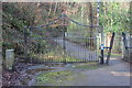
Centenary Gates, Abertillery Park
Gates, on the way to the football ground, celebrating the centenaries of Abertillery RFC (left) and Blaenau Gwent RFC (right). The route is part of the Ebbw Fach Trail and National Cycle Route 465.
Image: © M J Roscoe
Taken: 16 Feb 2018
0.12 miles
9

Ebbw Fach Trail, Abertillery Park
The footprint symbol on the wall, left, is the way marker for the trail; the lettering on the ground between the gate posts reads, 'Abertillery Park'. The metal railings running across the picture fence off the bowling green.
Image: © M J Roscoe
Taken: 16 Feb 2018
0.14 miles
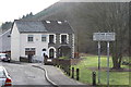
10
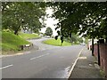
Road junction
Junction of Smith Road and Rose Hayworth Road.
Image: © Alan Hughes
Taken: 9 Aug 2021
0.15 miles