IMAGES TAKEN NEAR TO
Roseheyworth Business Park North, ABERTILLERY, NP13 1SX
Introduction
This page details the photographs taken nearby to Roseheyworth Business Park North, NP13 1SX by members of the Geograph project.
The Geograph project started in 2005 with the aim of publishing, organising and preserving representative images for every square kilometre of Great Britain, Ireland and the Isle of Man.

There are currently over 7.5m images from over14,400 individuals and you can help contribute to the project by visiting https://www.geograph.org.uk
Image Map
Images are licensed for reuse under creativecommons.org/licenses/by-sa/2.0
Notes
- Clicking on the map will re-center to the selected point.
- The higher the marker number, the further away the image location is from the centre of the postcode.
Image Listing (34 Images Found)
Images are licensed for reuse under creativecommons.org/licenses/by-sa/2.0
Image
Details
Distance
1
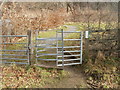
Bournville : kissing gate to a footpath through Forestry Commission land
The gate, on the edge of Bournville Road, is near the MoT centre. http://www.geograph.org.uk/photo/2256122
Image: © Jaggery
Taken: 3 Feb 2011
0.05 miles
2
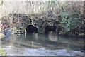
Old bridge, Ebbw Fach River
Disused overgrown bridge constructed to give access to the former South Griffin Colliery on the west bank.
Image: © M J Roscoe
Taken: 16 Feb 2018
0.06 miles
6
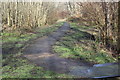
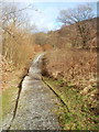
Ebbw Fach Trail near Roseheyworth Business Park
Path north from the west end of bridge Image carrying National Cycle Route 465.
Image: © M J Roscoe
Taken: 16 Feb 2018
0.09 miles
7
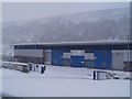
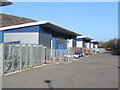
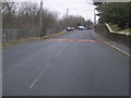
Looking towards the Civic Amenity Site
Image: © Nick Mutton 01329 000000
Taken: 15 Dec 2007
0.09 miles
8
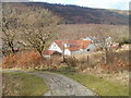
Bournville : detached house viewed from Forestry Commission land
Viewed from a footpath on the east side of Bournville Road. The house is adjacent to Bournville MoT Centre. http://www.geograph.org.uk/photo/2256122
Image: © Jaggery
Taken: 3 Feb 2011
0.11 miles
9
Bournville : footpath into Forestry Commission land
The footpath is on the east side of Bournville Road, accessed through a kissing gate. http://www.geograph.org.uk/photo/2256130
Image: © Jaggery
Taken: 3 Feb 2011
0.11 miles
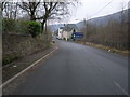
10
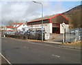
Bournville MoT centre
Located on Bournville Road, at the southern edge of the small community of Bournville, near Blaina.
Image: © Jaggery
Taken: 3 Feb 2011
0.11 miles