IMAGES TAKEN NEAR TO
West Bank, ABERTILLERY, NP13 1RE
Introduction
This page details the photographs taken nearby to West Bank, NP13 1RE by members of the Geograph project.
The Geograph project started in 2005 with the aim of publishing, organising and preserving representative images for every square kilometre of Great Britain, Ireland and the Isle of Man.

There are currently over 7.5m images from over14,400 individuals and you can help contribute to the project by visiting https://www.geograph.org.uk
Image Map
Images are licensed for reuse under creativecommons.org/licenses/by-sa/2.0
Notes
- Clicking on the map will re-center to the selected point.
- The higher the marker number, the further away the image location is from the centre of the postcode.
Image Listing (28 Images Found)
Images are licensed for reuse under creativecommons.org/licenses/by-sa/2.0
Image
Details
Distance
1
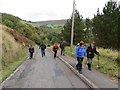
Heol Ty Dan y Wal Road
Cerddwyr yn dringo Heol Ty Dan y Wal.
Walkers ascending Ty dan y Wal Road (trans. house below the wall road).
Image: © Alan Richards
Taken: 12 Oct 2014
0.05 miles
2
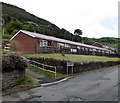
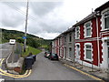
West Bank bungalows, Cwmtillery
Viewed across Ty-dan-y-wal Road.
Image: © Jaggery
Taken: 24 Jun 2013
0.08 miles
3
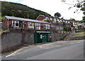
West Bank bus shelter and houses, Cwmtillery
Viewed across Ty-dan-y-wal Road.
Image: © Jaggery
Taken: 24 Jun 2013
0.09 miles
4
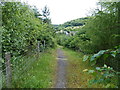
Path from West Bank towards East Bank, Cwmtillery
Viewed from the edge of Ty-dan-y-wal Road.
Image: © Jaggery
Taken: 24 Jun 2013
0.11 miles
5
Along Winifred Terrace, Cwmtillery
Winifred Terrace was formerly a route to Cwmtillery Colliery, which closed in 1982.
http://www.geograph.org.uk/photo/3526842 to another view of the houses.
Image: © Jaggery
Taken: 24 Jun 2013
0.15 miles
6
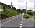
Ahead for West Bank, Cwmtillery
Ty-dan-y-wal Road is on the left. Winifred Terrace http://www.geograph.org.uk/photo/3526849 is on the right.
Image: © Jaggery
Taken: 24 Jun 2013
0.15 miles
7
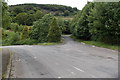
Road junction near Cwmtillery Lakes
On the right, the road from West Bank joins Ty-dan-y-wal Road.
Image: © Jaggery
Taken: 24 Jun 2013
0.16 miles
8
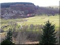
Cwm Tyleri
From St. Paul's churchyard, looking west to the quarry below Cefn Crib. The helicopter (G-LECA) belongs to South Wales Electricity Board and is on an inspection flight, typical of the area.
Image: © Graham Horn
Taken: 2 Feb 2008
0.16 miles
9
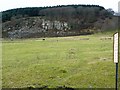
Quarry at Cefn Crib
The sign on the right gives details of its dangers, here Image]
Image: © Graham Horn
Taken: 2 Feb 2008
0.16 miles
10
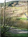
Lake and crags in Cwm Tyleri
This is an artificial lake created by the mine workings and now a nature reserve. Beyond are crags on the western slope of the valley at Cefn Crib.
Image: © Graham Horn
Taken: 2 Feb 2008
0.17 miles