IMAGES TAKEN NEAR TO
Palace Row, ABERTILLERY, NP13 1LQ
Introduction
This page details the photographs taken nearby to Palace Row, NP13 1LQ by members of the Geograph project.
The Geograph project started in 2005 with the aim of publishing, organising and preserving representative images for every square kilometre of Great Britain, Ireland and the Isle of Man.

There are currently over 7.5m images from over14,400 individuals and you can help contribute to the project by visiting https://www.geograph.org.uk
Image Map
Images are licensed for reuse under creativecommons.org/licenses/by-sa/2.0
Notes
- Clicking on the map will re-center to the selected point.
- The higher the marker number, the further away the image location is from the centre of the postcode.
Image Listing (69 Images Found)
Images are licensed for reuse under creativecommons.org/licenses/by-sa/2.0
Image
Details
Distance
1

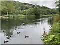
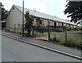
Roberts Row and Palace Row, Cwmtillery
Viewed from the left turn to the road along the edge of Cwmtillery Lakes.
Roberts Row is in the middle distance, Palace Row is in the background.
Image: © Jaggery
Taken: 24 Jun 2013
0.01 miles
2
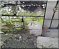
Ordnance Survey Cut Mark
This OS cut mark can be found on the wall of No4 Palace Row. It marks a point 303.899m above mean sea level.
Image: © Adrian Dust
Taken: 16 Feb 2024
0.01 miles
3
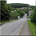
Road to Cwmtillery Lakes
Ty-dan-y-wal Road descends towards entrances on the left to the lakes.
Image: © Jaggery
Taken: 24 Jun 2013
0.02 miles
4
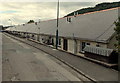
Eastern side of Roberts Row Cwmtillery
The houses are built on a terrace across steeply rising ground. The bases of the houses are below road level on this side. http://www.geograph.org.uk/photo/3530807 to a view of the western side.
Image: © Jaggery
Taken: 24 Jun 2013
0.03 miles
5
Western side of Roberts Row Cwmtillery
The houses are built on a terrace across steeply rising ground. The bases of the houses are below road level on the opposite side. http://www.geograph.org.uk/photo/3530809
Image: © Jaggery
Taken: 24 Jun 2013
0.03 miles
7
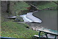
Weir, Cwmtillery Lake
Weir at end of southern lake, formerly a colliery reservoir, after heavy rain.
Image: © M J Roscoe
Taken: 23 Nov 2022
0.06 miles
8
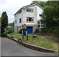
Vicarage, St Paul's church, Cwmtillery
Located in the southern corner of the churchyard.
Image: © Jaggery
Taken: 24 Jun 2013
0.07 miles
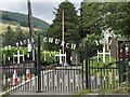
9
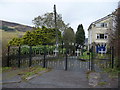
Access driveway to St. Paul's church, Cwmtillery
Access for the large graveyard I believe.
Image: © Jeremy Bolwell
Taken: 4 Nov 2012
0.07 miles