IMAGES TAKEN NEAR TO
Glan Y Nant, BLACKWOOD, NP12 3XG
Introduction
This page details the photographs taken nearby to NP12 3XG by members of the Geograph project.
The Geograph project started in 2005 with the aim of publishing, organising and preserving representative images for every square kilometre of Great Britain, Ireland and the Isle of Man.

There are currently over 7.5m images from over14,400 individuals and you can help contribute to the project by visiting https://www.geograph.org.uk
Image Map
Images are licensed for reuse under creativecommons.org/licenses/by-sa/2.0
Notes
- Clicking on the map will re-center to the selected point.
- The higher the marker number, the further away the image location is from the centre of the postcode.
Image Listing (184 Images Found)
Images are licensed for reuse under creativecommons.org/licenses/by-sa/2.0
Image
Details
Distance
1
Sorry No Dogs, Gwerthonor Road, Pengam
The red and white notice is on a wall near entrance gates to the Lewis School Pengam site.
Image: © Jaggery
Taken: 12 Aug 2019
0.01 miles
2
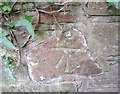
Ordnance Survey Cut Mark
This OS cut mark can be found on the wall east side of the road. It marks a point 155.043m above mean sea level.
Image: © Adrian Dust
Taken: 31 Aug 2019
0.01 miles
3
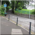
Gwerthonor Road, Pengam
Dead-end road on the north side of the B4254.
Image: © Jaggery
Taken: 7 Aug 2019
0.02 miles
4
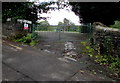
Pupil drop off/pickup point, Gwerthonor Road, Pengam
At an entrance path https://www.geograph.org.uk/photo/6236367 to Lewis School Pengam.
Image: © Jaggery
Taken: 12 Aug 2019
0.02 miles
5
Lineside cabinet northeast of Pengam station
Viewed from this https://www.geograph.org.uk/photo/6240371 path.
Image: © Jaggery
Taken: 17 Aug 2019
0.03 miles
6
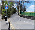
Southern end of Gwerthonor Road, Pengam
Gwerthonor Road heads north away from the B4254.
Image: © Jaggery
Taken: 1 May 2013
0.03 miles
7
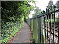
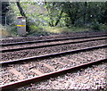
Lineside path from Pengam towards Gilfach
From the B4254 Pengam Road towards Gwerthonor Road in Gilfach.
The railings are at the edge of the railway between Pengam station and Gilfach Fargoed station.
Image: © Jaggery
Taken: 17 Aug 2019
0.04 miles
8
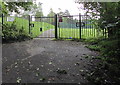
Path towards Lewis School Pengam
From these gates https://www.geograph.org.uk/photo/6236365 on the east side of Gwerthonor Road.
Image: © Jaggery
Taken: 12 Aug 2019
0.04 miles
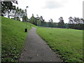
9
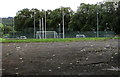
Towards playing fields, Lewis School Pengam
Viewed from these gates https://www.geograph.org.uk/photo/6236377 on the east side of Gwerthonor Road in Pengam.
Image: © Jaggery
Taken: 12 Aug 2019
0.04 miles
10
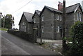
School House, Gwerthonor Road, Pengam
Stone house on the approach to Gilfach.
Image: © Jaggery
Taken: 12 Aug 2019
0.04 miles