IMAGES TAKEN NEAR TO
Railway View, BLACKWOOD, NP12 3UR
Introduction
This page details the photographs taken nearby to Railway View, NP12 3UR by members of the Geograph project.
The Geograph project started in 2005 with the aim of publishing, organising and preserving representative images for every square kilometre of Great Britain, Ireland and the Isle of Man.

There are currently over 7.5m images from over14,400 individuals and you can help contribute to the project by visiting https://www.geograph.org.uk
Image Map
Images are licensed for reuse under creativecommons.org/licenses/by-sa/2.0
Notes
- Clicking on the map will re-center to the selected point.
- The higher the marker number, the further away the image location is from the centre of the postcode.
Image Listing (37 Images Found)
Images are licensed for reuse under creativecommons.org/licenses/by-sa/2.0
Image
Details
Distance
1
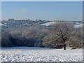
Snowy view across the Rhymney Valley
From Image looking west towards Hengoed.
Image: © Robin Drayton
Taken: 22 Dec 2009
0.16 miles
3
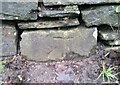
Ordnance Survey Cut Mark
This OS cut mark can be found on the wall east side of the A4049. It marks a point 169.396m above mean sea level.
Image: © Adrian Dust
Taken: 4 Feb 2021
0.18 miles
4
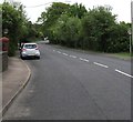
From 30 to 40 in Gellihaf
The 30mph speed limit on the A4049 increases to 40mph.
The Gellihaf boundary sign https://www.geograph.org.uk/photo/5776313 is nearby, behind the camera.
Image: © Jaggery
Taken: 16 May 2018
0.19 miles
5
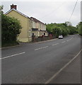
Gellihaf houses alongside the A4049
Viewed from near the Gellihaf boundary sign https://www.geograph.org.uk/photo/5776313 near the corner of Gellihaf Road in Fleur-de-lis.
Image: © Jaggery
Taken: 16 May 2018
0.19 miles
6
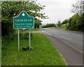
Fleur-de-lis - Please Drive Carefully
The sign alongside the A4049 faces Gellihaf. The smaller Gellihaf sign https://www.geograph.org.uk/photo/5776313 is on the back of this one.
The Caerphilly County Borough website records that this French name means iris or lily flower, adopted by royal families in France as a heraldic symbol. The name was given to the village in the 17th century by Huguenots from France who had fled religious persecution in their country. The name was an important link for them to their lost homeland. Though the name is often shown as Fleur de Lys or other variations, Fleur-de-lis is now used as the standard spelling by the local authority. Early records show the name as Flower-de-luce in 1833 and both Fleur-de-lis and the Welsh Trelyn in 1869. Locals often call the village Flower.
Image: © Jaggery
Taken: 16 May 2018
0.19 miles
7
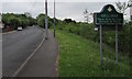
Gellihaf - Please Drive Carefully
The sign alongside the A4049 faces Fleur-de-lis near the corner of Gellihaf Road. The larger Fleur-de-lis sign https://www.geograph.org.uk/photo/5776321 is on the back of this one. Part of Caerphilly County Borough, Gellihaf is Welsh for summer grove or enclosure. When the area was mainly farms, the land around Gellihaf was used as summer grazing in the traditional Welsh way of farming as it is on a hillside rather than in the valley below.
Image: © Jaggery
Taken: 16 May 2018
0.19 miles
8
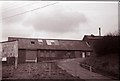
Gwent Abattoir
(Formerly The Co-Operative Abattoir)
Image: © Geographer
Taken: Unknown
0.20 miles
9
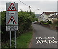
Warning signs at the southeast end of Gellihaf Road, Fleur-de-lis
Located here https://www.geograph.org.uk/photo/5776365 facing the A4049 junction.
Image: © Jaggery
Taken: 16 May 2018
0.20 miles
10
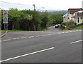
Junction of the A4049 and Gellihaf Road, Fleur-de-lis
From the A4049, Gellihaf Road descends into Fleur-de-lis.
The Gellihaf boundary sign https://www.geograph.org.uk/photo/5776313 is a few metres out of shot on the left.
Image: © Jaggery
Taken: 16 May 2018
0.20 miles