IMAGES TAKEN NEAR TO
The Twyn, BLACKWOOD, NP12 3UL
Introduction
This page details the photographs taken nearby to The Twyn, NP12 3UL by members of the Geograph project.
The Geograph project started in 2005 with the aim of publishing, organising and preserving representative images for every square kilometre of Great Britain, Ireland and the Isle of Man.

There are currently over 7.5m images from over14,400 individuals and you can help contribute to the project by visiting https://www.geograph.org.uk
Image Map
Images are licensed for reuse under creativecommons.org/licenses/by-sa/2.0
Notes
- Clicking on the map will re-center to the selected point.
- The higher the marker number, the further away the image location is from the centre of the postcode.
Image Listing (30 Images Found)
Images are licensed for reuse under creativecommons.org/licenses/by-sa/2.0
Image
Details
Distance
1
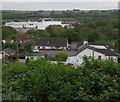
Towards Tir-y-berth Industrial Estate
Viewed from Gellihaf Road across the valley of the Rhymney River
Image: © Jaggery
Taken: 16 May 2018
0.14 miles
3
Lane towards School Street, Fleur-de-lis
Railings https://www.geograph.org.uk/photo/3444418 near the camera prevent motor vehicles accessing this route from Gellihaf Road to School Street.
Image: © Jaggery
Taken: 16 May 2018
0.19 miles
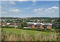
4
Blocked-off northern end of School Street, Fleur-de-lis
Viewed from Gellihaf Road in Fleur-de-lis, a village adjacent to Pengam, to the SE of Blackwood.
Image: © Jaggery
Taken: 3 May 2013
0.19 miles
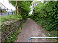
5
Path from Gellihaf Road to School Street, Fleur de Lys
Fleur de Lys is a village adjacent to Pengam, to the SE of Blackwood.
Image: © Jaggery
Taken: 3 May 2013
0.20 miles
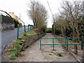
6
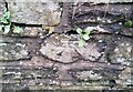
Ordnance Survey Cut Mark
This OS cut mark can be found on the wall east side of School Street. It marks a point 156.701m above mean sea level.
Image: © Adrian Dust
Taken: 4 Feb 2021
0.20 miles
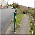
7
Yellow grit/salt box, Gellihaf Road, Fleur-de-lis
Alongside the long ascent from the centre of Fleur-de-lis.
Image: © Jaggery
Taken: 16 May 2018
0.20 miles
8
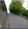
Wall, fence and railings, Fleur-de-lis
Alongside Gellihaf Road on the ascent away from the centre of Fleur-de-lis.
Image: © Jaggery
Taken: 16 May 2018
0.20 miles
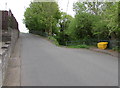
9

Slow on Gellihaf Road, Fleur de Lys
Gellihaf Road descends past the Bryngwyn Road junction towards the centre of Fleur de Lys,
a village adjacent to Pengam, to the SE of Blackwood. Araf is Welsh for slow.
Image: © Jaggery
Taken: 3 May 2013
0.20 miles
10
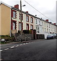
Buttry Terrace, Fleur de Lys
Buttry Terrace is a separately-named row of houses alongside Gellihaf Road
in Fleur de Lys, a village adjacent to Pengam, to the SE of Blackwood.
Some estate agents' websites refer to the houses as "Buttery Terrace"
whereas the street name sign and maps show Buttry Terrace.
Image: © Jaggery
Taken: 3 May 2013
0.21 miles