IMAGES TAKEN NEAR TO
High Street, BLACKWOOD, NP12 3UE
Introduction
This page details the photographs taken nearby to High Street, NP12 3UE by members of the Geograph project.
The Geograph project started in 2005 with the aim of publishing, organising and preserving representative images for every square kilometre of Great Britain, Ireland and the Isle of Man.

There are currently over 7.5m images from over14,400 individuals and you can help contribute to the project by visiting https://www.geograph.org.uk
Image Map
Images are licensed for reuse under creativecommons.org/licenses/by-sa/2.0
Notes
- Clicking on the map will re-center to the selected point.
- The higher the marker number, the further away the image location is from the centre of the postcode.
Image Listing (182 Images Found)
Images are licensed for reuse under creativecommons.org/licenses/by-sa/2.0
Image
Details
Distance
1
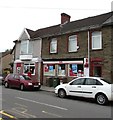
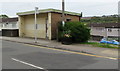
Fleur De Lis Post Office
At 47 High Street. The village name has several variant spellings - Fleur-de-lis or Fleur-de-lys with hyphens, or spaces instead of hyphens. De Lys/De Lis is sometimes spelt with initial capital letters, sometimes not.
Image: © Jaggery
Taken: 11 May 2018
0.01 miles
2
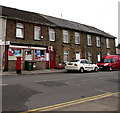
Fleur De Lis Post Office
Viewed across the B4252 High Street. A red Royal Mail van is on the right. The village name has several variant spellings - Fleur-de-lis or Fleur-de-lys with hyphens, or spaces instead of hyphens. De Lys/De Lis is sometimes spelt with initial capital letters, sometimes not.
Image: © Jaggery
Taken: 16 May 2018
0.01 miles
3
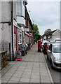
Pavement towards Fleur-de-lis Post Office
The red pillarbox is near the post office entrance on the east side of High Street.
The village name has several variant spellings - Fleur-de-lis or Fleur-de-lys with hyphens,
or spaces instead of hyphens. De Lys/De Lis is sometimes spelt with initial capital letters, sometimes not.
Image: © Jaggery
Taken: 11 May 2018
0.01 miles
4
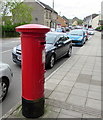
King George V pillarbox outside Fleur-de-lis post office
Located here. https://www.geograph.org.uk/photo/5774641
Image: © Jaggery
Taken: 11 May 2018
0.01 miles
5

Fleur de Lys Post Office
Located in High Street, Fleur de Lys, a village adjacent to Pengam, to the SE of Blackwood.
The spelling Fleur de Lis is also used, and sometimes with hyphens instead of spaces between the words.
I asked a local if he knew the reason for the French name for this village in Wales. He didn't know, but told me that the village is often referred to locally as Flower.
Image: © Jaggery
Taken: 3 May 2013
0.01 miles
6
Inconvenient in High Street, Fleur-de-lis
Viewed in May 2018. A notice shows that the toilets formerly in the bus
shelter near the corner of Gwent Court have been closed since April 1st 2014.
Image: © Jaggery
Taken: 11 May 2018
0.02 miles
7

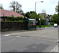
BT phonebox on a Fleur-de-lis corner
On the corner of High Street and Gwent Court.
Image: © Jaggery
Taken: 11 May 2018
0.02 miles
8
High Street speed bump, Fleur-de-lis
Across the B4252 High Street near a bus stop and shelter near the corner of Plas Road.
Image: © Jaggery
Taken: 11 May 2018
0.02 miles
9
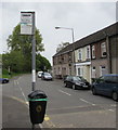
Gwent Court bus stop sign, High Street, Fleur-de-lis
The High Street stop, southeast of Gwent Court, http://www.geograph.org.uk/photo/5770383 is on bus route 14 from Bargoed to Blackwood.
In May 2018, buses on this route are operated by Stagecoach and Harris Coaches.
Image: © Jaggery
Taken: 11 May 2018
0.02 miles
10
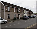
Row of houses, High Street, Fleur-de-lis
On the west side of the B4252 High Street opposite the Plas Road junction.
Image: © Jaggery
Taken: 11 May 2018
0.03 miles