IMAGES TAKEN NEAR TO
Newbridge Road Industrial Estate, BLACKWOOD, NP12 2YN
Introduction
This page details the photographs taken nearby to Newbridge Road Industrial Estate, NP12 2YN by members of the Geograph project.
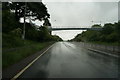
The Geograph project started in 2005 with the aim of publishing, organising and preserving representative images for every square kilometre of Great Britain, Ireland and the Isle of Man.

There are currently over 7.5m images from over14,400 individuals and you can help contribute to the project by visiting https://www.geograph.org.uk
Image Map
Images are licensed for reuse under creativecommons.org/licenses/by-sa/2.0
Notes
- Clicking on the map will re-center to the selected point.
- The higher the marker number, the further away the image location is from the centre of the postcode.
Image Listing (62 Images Found)
Images are licensed for reuse under creativecommons.org/licenses/by-sa/2.0
Image
Details
Distance
1
Road from Pentwynmawr to Oakdale unsuitable for HGVs
A sign at a left turn on the western edge of Pentwynmawr advises HGV (heavy goods vehicle) drivers to ignore satellite navigation. The 2 kilometre country road north to Oakdale is narrow, bendy and steep, ascending more than 100 metres.
Image: © Jaggery
Taken: 16 Aug 2010
0.05 miles
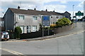
2
Maesteg bungalows, Pentwynmawr
A long line of bungalows on the north side of High Street, Pentwynmawr, is named Maesteg at the location, though some maps shown Maes Teg.
Image: © Jaggery
Taken: 16 Aug 2010
0.08 miles
4
SE end of Sirhowy Enterprise Way, Pontllanfraith
The view NW along the A4048 from the edge of a roundabout.
Sirhowy Enterprise Way gives a direct route from the north of Blackwood to the east of Pontllanfraith, and also to Oakdale Business Park, on the site of the former Oakdale Colliery.
Image: © Jaggery
Taken: 23 Jan 2011
0.08 miles
5
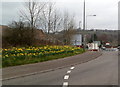
Bank of daffodils, Pontllanfraith
Viewed along the edge of the A4048 in mid March 2012.
Image: © Jaggery
Taken: 16 Mar 2012
0.10 miles
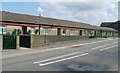
6
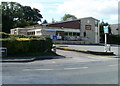
White Hart, Pentwynmawr
Pub on the western edge of the village, on Newbridge Road.
http://www.geograph.org.uk/photo/2249791 to a closeup of the pub sign.
Image: © Jaggery
Taken: 16 Aug 2010
0.11 miles
7
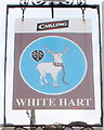
Pub sign, White Hart, Pentwynmawr
The White Hart http://www.geograph.org.uk/photo/2017216 pub sign is located on a metal post near the roadside, close to the point where Newbridge Road is renamed High Street Pentwynmawr.
Image: © Jaggery
Taken: 23 Jan 2011
0.11 miles
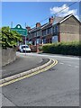
8
Western boundary of Pentwynmawr
Newbridge Road, from Pontllanfraith, becomes High Street Pentwynmawr on entering the village.
Image: © Jaggery
Taken: 16 Aug 2010
0.12 miles
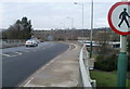
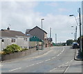
10
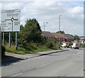
Newbridge Road heading west away from Pentwynmawr
A few metres behind the camera, High Street Pentwynmawr is renamed Newbridge Road on leaving the village. Straight ahead (around the roundabout) for Pontllanfraith http://www.geograph.org.uk/photo/2016959 and Sainsbury's. http://www.geograph.org.uk/photo/2016911
Image: © Jaggery
Taken: 16 Aug 2010
0.13 miles