IMAGES TAKEN NEAR TO
Newbridge Road Industrial Estate, BLACKWOOD, NP12 2YL
Introduction
This page details the photographs taken nearby to Newbridge Road Industrial Estate, NP12 2YL by members of the Geograph project.
The Geograph project started in 2005 with the aim of publishing, organising and preserving representative images for every square kilometre of Great Britain, Ireland and the Isle of Man.

There are currently over 7.5m images from over14,400 individuals and you can help contribute to the project by visiting https://www.geograph.org.uk
Image Map
Images are licensed for reuse under creativecommons.org/licenses/by-sa/2.0
Notes
- Clicking on the map will re-center to the selected point.
- The higher the marker number, the further away the image location is from the centre of the postcode.
Image Listing (20 Images Found)
Images are licensed for reuse under creativecommons.org/licenses/by-sa/2.0
Image
Details
Distance
1
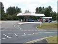
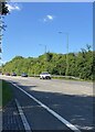
Sainsbury's filling station, Pontllanfraith
Located at the western end of Sainsbury's superstore http://www.geograph.org.uk/photo/2016911 which opened on the former Somerfield site on the north side of Newbridge Road in 2009.
Image: © Jaggery
Taken: 16 Aug 2010
0.08 miles
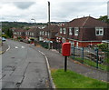
2
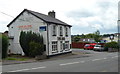
Ivor Arms Pontllanfraith
Pub located on the south side of Newbridge Road near the corner of Millbrook Road.
Image: © Jaggery
Taken: 8 Aug 2012
0.10 miles
3
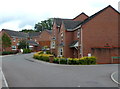
Cwm Braenar, Pontllanfraith
Cwm Braenar houses viewed from the corner of Vicarage Lane.
Image: © Jaggery
Taken: 8 Aug 2012
0.11 miles
4
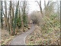
Path to Cwm Philkins, Pontllanfraith
Viewed from near the Newbridge Road end, a path heads towards Cwm Philkins, the site of a former Sirhowy Valley colliery. A variant spelling is Filkins.
Image: © Jaggery
Taken: 23 Jan 2011
0.12 miles
6
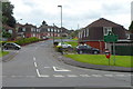
Northern boundary of Springfield, Pontllanfraith
Viewed across Newbridge Road (B4251). Millbrook Road heads south into the Springfield district of Pontllanfraith.
Image: © Jaggery
Taken: 8 Aug 2012
0.12 miles
7

Sainsbury's Pontllanfraith
The superstore opened in 2009 on a site on the north side of Newbridge Road formerly occupied by a Somerfield store.
Image: © Jaggery
Taken: 16 Aug 2010
0.12 miles
8
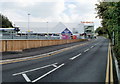
Perimeter road, Sainsbury's, Pontllanfraith
The road, on the southern edge of the Newbridge Road site, leads from the superstore to the filling station http://www.geograph.org.uk/photo/2016897 and exit.
Image: © Jaggery
Taken: 16 Aug 2010
0.12 miles
9
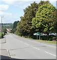
Pontllanfraith boundary sign
Shaded by trees, a green sign asks you to please drive carefully in Pontllanfraith.
Behind the trees is a Sainsbury's superstore. http://www.geograph.org.uk/photo/2016911 Behind the camera are newly-built flats.
http://www.geograph.org.uk/photo/2016947
Image: © Jaggery
Taken: 16 Aug 2010
0.12 miles
10
Meadow Road, Springfield, Pontllanfraith
Houses on the north side of the road viewed from the corner of Millbrook Road.
Image: © Jaggery
Taken: 8 Aug 2012
0.14 miles