IMAGES TAKEN NEAR TO
Cwmalsie Lane, BLACKWOOD, NP12 2LX
Introduction
This page details the photographs taken nearby to Cwmalsie Lane, NP12 2LX by members of the Geograph project.
The Geograph project started in 2005 with the aim of publishing, organising and preserving representative images for every square kilometre of Great Britain, Ireland and the Isle of Man.

There are currently over 7.5m images from over14,400 individuals and you can help contribute to the project by visiting https://www.geograph.org.uk
Image Map
Images are licensed for reuse under creativecommons.org/licenses/by-sa/2.0
Notes
- Clicking on the map will re-center to the selected point.
- The higher the marker number, the further away the image location is from the centre of the postcode.
Image Listing (24 Images Found)
Images are licensed for reuse under creativecommons.org/licenses/by-sa/2.0
Image
Details
Distance
1
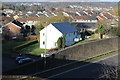
House next to A472, Pontllanfraith
Pontllanfraith viewed from a road bridge (shadow at bottom of picture) over the A472 dual carriageway.
Image: © M J Roscoe
Taken: 17 Nov 2018
0.04 miles
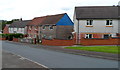
3
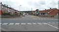
Mill Road, Springfield, Pontllanfraith
Viewed from Millbrook Road at the Woodland Road crossroads.
Image: © Jaggery
Taken: 8 Aug 2012
0.13 miles
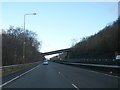
4
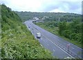
The A472 from Newbridge to Hengoed
Looking south west, near Pontllanfraith.
Image: © Roger Cornfoot
Taken: 10 May 2007
0.13 miles
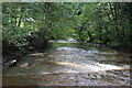
5
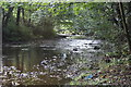
River Sirhowy, Pontllanfraith
Looking downstream.
Image: © M J Roscoe
Taken: 22 Sep 2016
0.16 miles
6
Woodland Road houses, Springfield, Pontllanfraith
Houses on the north side of Woodland Road viewed from the Millbrook Road and Mill Road crossroads.
Image: © Jaggery
Taken: 8 Aug 2012
0.18 miles
7
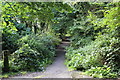
Sirhowy Valley Walk, Pontllanfraith
Long distance path going south from near the eastern end of Pen-llwyn Avenue Image The vegetation in early autumn appears to have encroached on both sides of the path.
Image: © M J Roscoe
Taken: 22 Sep 2016
0.20 miles
8
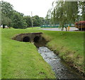
Nant Brynar, Islwyn Park, Pontllanfraith
A stream, Nant Brynar, enters a twin-bore culvert under the entrance road into Islwyn Park.
Nant Brynar is a tributary of the Sirhowy, into which it flows about 200 metres ahead.
Image: © Jaggery
Taken: 8 Aug 2012
0.21 miles
9
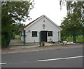
St John Ambulance Hall, Llanarth Road, Pontllanfraith
Located in a locked enclosure a few metres north of the Woodland Road junction.
Image: © Jaggery
Taken: 8 Aug 2012
0.21 miles
10
Weir, River Sirhowy, Pontllanfraith
Looking downstream over a small weir, from the same camera position as Image
Image: © M J Roscoe
Taken: 22 Sep 2016
0.21 miles