IMAGES TAKEN NEAR TO
Gerddi Ty Mawr, BLACKWOOD, NP12 2GY
Introduction
This page details the photographs taken nearby to Gerddi Ty Mawr, NP12 2GY by members of the Geograph project.
The Geograph project started in 2005 with the aim of publishing, organising and preserving representative images for every square kilometre of Great Britain, Ireland and the Isle of Man.

There are currently over 7.5m images from over14,400 individuals and you can help contribute to the project by visiting https://www.geograph.org.uk
Image Map
Images are licensed for reuse under creativecommons.org/licenses/by-sa/2.0
Notes
- Clicking on the map will re-center to the selected point.
- The higher the marker number, the further away the image location is from the centre of the postcode.
Image Listing (82 Images Found)
Images are licensed for reuse under creativecommons.org/licenses/by-sa/2.0
Image
Details
Distance
1
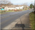
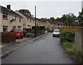
Southern boundary of Pontllanfraith
Viewed across Newport Road (A4048). The white-on-green Pontllanfraith sign is on the corner of Gelli Lane.
Image: © Jaggery
Taken: 23 Jan 2011
0.03 miles
2
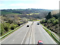
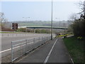
A472 approaches Gelligroes Roundabout
The view from a footbridge. http://www.geograph.org.uk/photo/2359581
Image: © Jaggery
Taken: 7 Apr 2011
0.04 miles
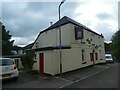
4
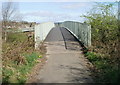
Footbridge over the A472, Upper Gelligroes, Pontllanfraith
This (southern) side of the footbridge is near The Halfway House. http://www.geograph.org.uk/photo/2359575
The far side of the footbridge leads to Gelligroes Road.
Image: © Jaggery
Taken: 7 Apr 2011
0.05 miles
5
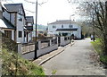
Central section of Gerddi Ty Mawr, Upper Gelligroes
Houses located near The Halfway House. http://www.geograph.org.uk/photo/2359575
Image: © Jaggery
Taken: 7 Apr 2011
0.05 miles
6
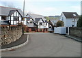
Houses at the northern end of Gerddi Ty Mawr, Upper Gelligroes
The northern end of the road named Gerddi Ty Mawr is near a footbridge http://www.geograph.org.uk/photo/2359581 over the A472.
The Halfway House http://www.geograph.org.uk/photo/2359575 is ahead, out of shot around the corner.
Image: © Jaggery
Taken: 7 Apr 2011
0.05 miles
8
Marshfield Court, Pontllanfraith
Cul-de-sac on the west side of Gelli Lane.
Image: © Jaggery
Taken: 20 Jun 2018
0.07 miles
9
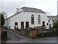
Siloh Presbyterian Church, Gelligroes
Erected in 1813.
Siloh (Shiloh) is a biblical place name as recorded in Judges 18:1 "The whole assembly of the Israelites gathered at Shiloh and set up the Tent of Meeting there."
Image: © Robin Drayton
Taken: 20 Mar 2010
0.08 miles
10
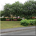
Benches under trees near Gelli Lane, Pontllanfraith
Set back from the south side of Gelli Lane.
Image: © Jaggery
Taken: 20 Jun 2018
0.08 miles