1
Mill Road, Springfield, Pontllanfraith
Viewed from Millbrook Road at the Woodland Road crossroads.
Image: © Jaggery
Taken: 8 Aug 2012
0.01 miles
2
Woodland Road houses, Springfield, Pontllanfraith
Houses on the north side of Woodland Road viewed from the Millbrook Road and Mill Road crossroads.
Image: © Jaggery
Taken: 8 Aug 2012
0.06 miles
3
Mussel White Court, Springfield, Pontllanfraith
Mussel White Court is a small cul-de-sac of 14 houses, viewed from Millbrook Road.
Image: © Jaggery
Taken: 8 Aug 2012
0.10 miles
4
Alder Rise, Springfield, Pontllanfraith
Viewed from the corner of Brook Lane and Millbrook Road.
Image: © Jaggery
Taken: 8 Aug 2012
0.13 miles
5
Islwyn Terrace, Pontllanfraith
Islwyn Terrace is a separately-named part of Llanarth Road.
Image: © Jaggery
Taken: 8 Aug 2012
0.13 miles
6
St John Ambulance Hall, Llanarth Road, Pontllanfraith
Located in a locked enclosure a few metres north of the Woodland Road junction.
Image: © Jaggery
Taken: 8 Aug 2012
0.14 miles
7
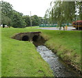
Nant Brynar, Islwyn Park, Pontllanfraith
A stream, Nant Brynar, enters a twin-bore culvert under the entrance road into Islwyn Park.
Nant Brynar is a tributary of the Sirhowy, into which it flows about 200 metres ahead.
Image: © Jaggery
Taken: 8 Aug 2012
0.14 miles
8
Disused grandstand, Islwyn Park, Pontllanfraith
Islwyn Park is the home ground of Pontllanfraith Rugby Football Club.
The grandstand is located in the SE corner of the park. A notice on the side wall of the grandstand shows DANGEROUS STRUCTURE KEEP OUT.
Image: © Jaggery
Taken: 8 Aug 2012
0.15 miles
9
House next to A472, Pontllanfraith
Pontllanfraith viewed from a road bridge (shadow at bottom of picture) over the A472 dual carriageway.
Image: © M J Roscoe
Taken: 17 Nov 2018
0.15 miles
10
Rugby pitch, Islwyn Park, Pontllanfraith
This is the home ground of Pontllanfraith Rugby Football Club.
A disused grandstand http://www.geograph.org.uk/photo/3073987 is on the left.
Image: © Jaggery
Taken: 8 Aug 2012
0.15 miles


