IMAGES TAKEN NEAR TO
Heol Cwm Dows, BLACKWOOD, NP12 2AU
Introduction
This page details the photographs taken nearby to Heol Cwm Dows, NP12 2AU by members of the Geograph project.
The Geograph project started in 2005 with the aim of publishing, organising and preserving representative images for every square kilometre of Great Britain, Ireland and the Isle of Man.

There are currently over 7.5m images from over14,400 individuals and you can help contribute to the project by visiting https://www.geograph.org.uk
Image Map
Images are licensed for reuse under creativecommons.org/licenses/by-sa/2.0
Notes
- Clicking on the map will re-center to the selected point.
- The higher the marker number, the further away the image location is from the centre of the postcode.
Image Listing (25 Images Found)
Images are licensed for reuse under creativecommons.org/licenses/by-sa/2.0
Image
Details
Distance
1
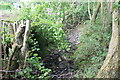
Nant Philkins
A stream in Cwm Philkins just north of stile Image
Image: © M J Roscoe
Taken: 3 Jun 2017
0.13 miles
2
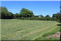
Mown grass field, Pant-yr-yn
Recently mown field; there is a public footpath on the far side of the hedge.
Image: © M J Roscoe
Taken: 19 May 2020
0.13 miles
3
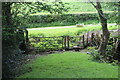
Gate and stile near private road
A footpath (possibly a byway) runs downhill to a stile and a public footpath on to the private road in front of the hedge. In front of the gate the track crosses a culvert carrying the Nant Philkins Image
Image: © M J Roscoe
Taken: 3 Jun 2017
0.13 miles
4
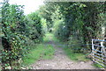
Footpath to Cyncoed Farm
The first part of the field footpath follows a track to the first stile, just visible centre background.
Image: © M J Roscoe
Taken: 9 Sep 2015
0.14 miles
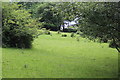
5
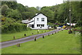
House in Cwm Philkins
House in valley at the end of a private road; a plaque on the wall says, '1911'. A public footpath runs along the road to a field Image
Image: © M J Roscoe
Taken: 3 Jun 2017
0.15 miles
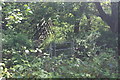
6
Overgrown stile near Pen-twyn Farm
Little used wooden stile to field footpath.
Image: © M J Roscoe
Taken: 3 Jun 2017
0.16 miles
7
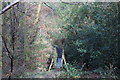
Footbridge, Nant Philkins, Cwm Philkins
Footpath from Tir Philkins to farm road.
Image: © M J Roscoe
Taken: 11 Feb 2016
0.17 miles
8
Footbridge over Nant Philkins
Gate and bridge on public footpath towards Tir-Filkins Farm.
Image: © M J Roscoe
Taken: 19 May 2020
0.17 miles
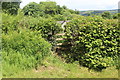
9
Pasture on the east of Cwm Philkins
A public footpath runs down across the field to the stile (background centre), but is not evident on the ground. The field is part of the Cyncoed Fields Site of Importance for Nature Conservation.
Image: © M J Roscoe
Taken: 3 Jun 2017
0.17 miles
10
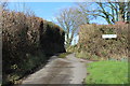
Lane to Pentwyn Farm
Lane from minor road.
Image: © M J Roscoe
Taken: 11 Feb 2016
0.18 miles