IMAGES TAKEN NEAR TO
High Street, BLACKWOOD, NP12 1BE
Introduction
This page details the photographs taken nearby to High Street, NP12 1BE by members of the Geograph project.
The Geograph project started in 2005 with the aim of publishing, organising and preserving representative images for every square kilometre of Great Britain, Ireland and the Isle of Man.

There are currently over 7.5m images from over14,400 individuals and you can help contribute to the project by visiting https://www.geograph.org.uk
Image Map
Images are licensed for reuse under creativecommons.org/licenses/by-sa/2.0
Notes
- Clicking on the map will re-center to the selected point.
- The higher the marker number, the further away the image location is from the centre of the postcode.
Image Listing (108 Images Found)
Images are licensed for reuse under creativecommons.org/licenses/by-sa/2.0
Image
Details
Distance
1
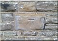
Ordnance Survey Cut Mark
This OS cut mark can be found on the NE face of St Margaret's Church. It marks a point 175.095m above mean sea level.
Image: © Adrian Dust
Taken: 5 Feb 2021
0.03 miles
5
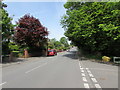
North along Pentwyn Avenue, Blackwood
Towards Sunnybank Road. The Pentwyn Court junction https://www.geograph.org.uk/photo/5778176 is on the right.
Image: © Jaggery
Taken: 17 May 2018
0.05 miles
6
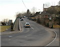
Sunnybank Road, Blackwood
Sunnybank Road climbs away from the edge of the Chartist Bridge roundabout, heading for Cefn Fforest.
Image: © Jaggery
Taken: 1 Mar 2010
0.06 miles
7
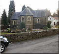
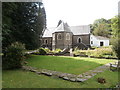
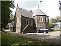
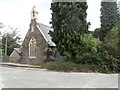
St Margaret's Church, Blackwood
Located near the north end of High Street, Blackwood, set back about 20 metres from the west side of the street. The view of the front of the church from High Street (from the east) is obscured by trees, so this view is from the northeast through a gap in the trees.
Image: © Jaggery
Taken: 1 Mar 2010
0.07 miles
8
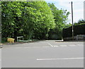
Pentwyn Court, Blackwood
Cul-de-sac below the east side of Pentwyn Avenue.
Image: © Jaggery
Taken: 17 May 2018
0.07 miles
9
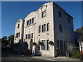
Blackwood Miner's Welfare Institute
Known as Blackwood Miners' Institute. Funded by threepence deductions from local miner's weekly wagepackets and is dated 1925 - the year prior to the General Strike. In its early heyday it offered dances, snooker and billiards tables, reading rooms, library, rehearsal rooms and meeting rooms for local clubs, groups and societies, a ladies room, stage and auditorium and a focal point for the town. It fell into disrepair and decay in the 1970's and 1980's and was taken over by the local council who regenerated it and today it enjoys a second heyday.
Here two lady joggers run by on a sunny autumn Sunday morning.
Image: © Jeremy Bolwell
Taken: 14 Oct 2012
0.09 miles
10
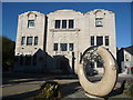
Blackwood Miners Institute
With a lovely piece of public art - a sculpture of a ring doughnut with a bite taken out and then discarded, symbolising the sweetness and satisfaction of life and how this is often overlooked in our shallow existences where we are so easily distracted by the next thing to catch our eye or stimulate our tastebuds.
I expect. Or something else altogether. Who knows?
Image: © Jeremy Bolwell
Taken: 14 Oct 2012
0.09 miles