IMAGES TAKEN NEAR TO
High Street, BLACKWOOD, NP12 1AF
Introduction
This page details the photographs taken nearby to High Street, NP12 1AF by members of the Geograph project.
The Geograph project started in 2005 with the aim of publishing, organising and preserving representative images for every square kilometre of Great Britain, Ireland and the Isle of Man.

There are currently over 7.5m images from over14,400 individuals and you can help contribute to the project by visiting https://www.geograph.org.uk
Image Map
Images are licensed for reuse under creativecommons.org/licenses/by-sa/2.0
Notes
- Clicking on the map will re-center to the selected point.
- The higher the marker number, the further away the image location is from the centre of the postcode.
Image Listing (326 Images Found)
Images are licensed for reuse under creativecommons.org/licenses/by-sa/2.0
Image
Details
Distance
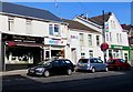
1
The Foresters Nightclub in Blackwood town centre
At 110 High Street, viewed in August 2016. The New Foresters pub was here in March 2010. http://www.geograph.org.uk/photo/1732168
Image: © Jaggery
Taken: 15 Aug 2016
0.01 miles
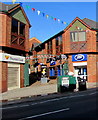
2
Boots in Blackwood town centre
The High Street side of the Boots shop at 2 The Market Place.
Image: © Jaggery
Taken: 15 Aug 2016
0.01 miles
3
Eastern entrance to The Market Place, Blackwood
From High Street, between Thomas Cook and Boots.
Image: © Jaggery
Taken: 15 Aug 2016
0.01 miles
4
Lloyds Bank, Blackwood
The High Street bank was previously Lloyds TSB, http://www.geograph.org.uk/photo/1732153 rebranded Lloyds Bank in September 2013.
Image: © Jaggery
Taken: 18 Feb 2014
0.01 miles
5
Lloyds Bank, Blackwood
Bank branch at 112 High Street.
Image: © Jaggery
Taken: 15 Aug 2016
0.01 miles
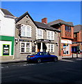
6
Part of High Street, Blackwood
Blackwood has always been a busy, lively town and unlike many valleys towns does not seem to have many, or indeed any, closed or empty shops. I may be wrong as a visit on a Sunday morning is not the best time to assess traders premises.
Image: © Jeremy Bolwell
Taken: 14 Oct 2012
0.01 miles
7
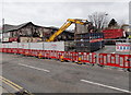
Demolition site (2), High Street, Blackwood
The site is on the corner of High Street and Woodbine Road. In the early hours of May 1st 2013, a large fire severely damaged the Poundstretcher store. Dozens of firefighters tackled the blaze, which closed High Street. A large plume of smoke rose above the town.
This view, taken 2 days later, shows that the Poundstretcher store has already been mostly demolished. It appears that the Timpson shoe shop on the left will also be demolished as a result of fire damage.
Image: © Jaggery
Taken: 3 May 2013
0.02 miles
8
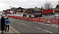
Demolition site (3), High Street, Blackwood
The site is on the corner of High Street and Woodbine Road. In the early hours of May 1st 2013, a large fire severely damaged the Poundstretcher store. Dozens of firefighters tackled the blaze, which closed High Street. A large plume of smoke rose above the town.
This view, taken 2 days later, shows that the Poundstretcher store has already been mostly demolished. It appears that the Timpson shoe shop on the left will also be demolished as a result of fire damage.
Image: © Jaggery
Taken: 3 May 2013
0.02 miles
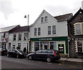
9
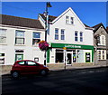
Woolleys Florist, Blackwood
At 118 High Street. Lloyds Bank http://www.geograph.org.uk/photo/5074887 is on the right.
Image: © Jaggery
Taken: 15 Aug 2016
0.02 miles
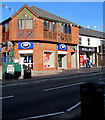
10

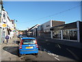
Quikstop in Blackwood town centre
Discount store at 116 High Street. Also in view are Woolleys Florist and Edwards Travel.
Image: © Jaggery
Taken: 15 Aug 2016
0.02 miles