1
Entrance to Upper Sirhowy Valley Community Woodlands, Hollybush
The gateways to the woodlands were designed by Rubin Eynon using Welsh oak, pennant sandstone and iron.
The steam locomotive is a reminder that a busy railway line from Tredegar to Newport once ran through the valley.
The woodlands were opened by HRH The Princess Royal in 2008.
Image: © Robin Drayton
Taken: 1 Apr 2014
0.03 miles
2
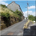
Turning area at the northern end of Railway Terrace, Hollybush
500 metres NNE of its junction with the A4048, http://www.geograph.org.uk/photo/3580212 Railway Terrace ends here.
Image: © Jaggery
Taken: 1 Aug 2013
0.04 miles
3
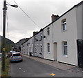
Row of houses at the northern end of Railway Terrace, Hollybush
The houses face the wooded valley of the Sirhowy River.
Image: © Jaggery
Taken: 1 Aug 2013
0.04 miles
4
The Sirhowy Valley at Hollybush
The terrace of houses in the centre is William Street.
The River Sirhowy flows behind these houses.
The route of the former railway is visible from in front of the modern building on the left with the former station building http://www.geograph.org.uk/photo/2168291 in the distance.
Image: © Robin Drayton
Taken: 16 Nov 2010
0.04 miles
5
William Street, Hollybush
A 40 metre long row of houses on the west bank of a river, the Sirhowy. Viewed from Railway Terrace.
Image: © Jaggery
Taken: 1 Aug 2013
0.05 miles
6
Railway Cottages, Railway Terrace, Hollybush
Railway Cottages are set above the roadway on the west side of Railway Terrace.
Image: © Jaggery
Taken: 1 Aug 2013
0.06 miles
7
Northern end of Railway Terrace, Hollybush
Looking south from this http://www.geograph.org.uk/photo/3580350 turning area.
Image: © Jaggery
Taken: 1 Aug 2013
0.06 miles
8
A4048 heads north away from Hollybush
Heading north towards Tredegar, the A4048 approaches a left turn for a private road. http://www.geograph.org.uk/photo/3579166
Image: © Jaggery
Taken: 1 Aug 2013
0.07 miles
9
A4048 looking north at Hollybush
Image: © Colin Pyle
Taken: 2 Jan 2012
0.07 miles
10
Footpath through the woodlands, Hollybush
This path leads down from the entrance to the woodlands http://www.geograph.org.uk/photo/3916969 to the River Sirhowy http://www.geograph.org.uk/photo/3916973 .
Image: © Robin Drayton
Taken: 1 Apr 2014
0.07 miles


