IMAGES TAKEN NEAR TO
Markham, BLACKWOOD, NP12 0RY
Introduction
This page details the photographs taken nearby to NP12 0RY by members of the Geograph project.
The Geograph project started in 2005 with the aim of publishing, organising and preserving representative images for every square kilometre of Great Britain, Ireland and the Isle of Man.

There are currently over 7.5m images from over14,400 individuals and you can help contribute to the project by visiting https://www.geograph.org.uk
Image Map
Images are licensed for reuse under creativecommons.org/licenses/by-sa/2.0
Notes
- Clicking on the map will re-center to the selected point.
- The higher the marker number, the further away the image location is from the centre of the postcode.
Image Listing (7 Images Found)
Images are licensed for reuse under creativecommons.org/licenses/by-sa/2.0
Image
Details
Distance
1
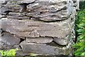
Ordnance Survey Cut Mark
This OS cut mark can be found on the wall east side of Commin Road. It marks a point 319.875m above mean sea level.
Image: © Adrian Dust
Taken: 20 Jul 2019
0.04 miles
4
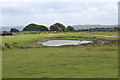
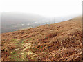
Pond near road junction on ridge
Pond partly covering track, Coed-y-Moeth Common.
Image: © M J Roscoe
Taken: 5 Jul 2020
0.22 miles
5
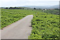
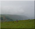
Minor road across Coed-y-Moeth Common
Unfenced road above Brithdir.
Image: © M J Roscoe
Taken: 5 Jul 2020
0.22 miles
6
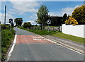
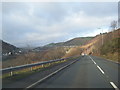
End of the 30mph speed limit at the NW edge of Markham
Viewed along Heol-y-Bedw-Hirion near the Cherry Trees http://www.geograph.org.uk/photo/3491312 turning.
In the background, centre right, is a large water storage tank. http://www.geograph.org.uk/photo/3491304
Image: © Jaggery
Taken: 1 Jun 2013
0.23 miles