IMAGES TAKEN NEAR TO
Heol-y-Bedw-Hirion, NP12 0RU
Introduction
This page details the photographs taken nearby to Heol-y-Bedw-Hirion, NP12 0RU by members of the Geograph project.
The Geograph project started in 2005 with the aim of publishing, organising and preserving representative images for every square kilometre of Great Britain, Ireland and the Isle of Man.

There are currently over 7.5m images from over14,400 individuals and you can help contribute to the project by visiting https://www.geograph.org.uk
Image Map
Images are licensed for reuse under creativecommons.org/licenses/by-sa/2.0
Notes
- Clicking on the map will re-center to the selected point.
- The higher the marker number, the further away the image location is from the centre of the postcode.
Image Listing (26 Images Found)
Images are licensed for reuse under creativecommons.org/licenses/by-sa/2.0
Image
Details
Distance
1
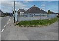
Markham Medical Centre
Located in a pyramid-like building inside a fenced compound at the SW edge of James Street.
Image: © Jaggery
Taken: 1 Jun 2013
0.02 miles
2
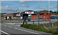
Blackwood Automotive Ltd, Markham
Located near James Street alongside the road north from Bedwellty.
The business undertakes car accident repairs and resprays, and mechanical work.
Image: © Jaggery
Taken: 1 Jun 2013
0.04 miles
3
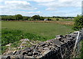
Field at the southern edge of Markham
Viewed from the road from Bedwellty. The land here is about 300 metres or nearly 1,000 feet above sea level.
Image: © Jaggery
Taken: 1 Jun 2013
0.06 miles
4
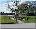
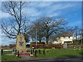
Markham War Memorial
Located on a triangular green on the south side of the B4511 Pantycefn Road.
Image: © Jaggery
Taken: 1 Jun 2013
0.07 miles
5
War Memorial, Markham (1)
Situated at a road junction on the western outskirts of Markham.
For a closer view see http://www.geograph.org.uk/photo/3912938 .
Image: © Robin Drayton
Taken: 1 Apr 2014
0.07 miles
6
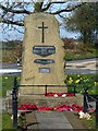
War Memorial, Markham (2)
The three plaques name local residents who died in World War II, the Korean War and the Northern Ireland Troubles.
Image: © Robin Drayton
Taken: 1 Apr 2014
0.07 miles
7
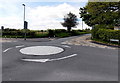
Round and round we go, Markham
The mini-roundabout is at the junction of the B4511 Pantycefn Road and Heol-y-Bedw-Hirion.
Image: © Jaggery
Taken: 1 Jun 2013
0.08 miles
8
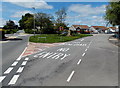
One-way system in Markham
A one-way system operates around this grass triangle.
Markham War Memorial http://www.geograph.org.uk/photo/3491246 is at the right edge of the triangle.
Image: © Jaggery
Taken: 1 Jun 2013
0.08 miles
9
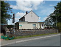
Markham Resource Centre, Markham
The former Markham police station in Heol-y-Bedw-Hirion is now Caerphilly County Borough Council premises in use as a base to support adults with learning disabilities.
Image: © Jaggery
Taken: 1 Jun 2013
0.09 miles
10
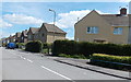
James Street, Markham
The houses are opposite playing fields and a school.
Image: © Jaggery
Taken: 1 Jun 2013
0.10 miles