1
Woodfieldside
Larger cottages on the steep east side of the Sirhowy valley.
Image: © Jonathan Billinger
Taken: 28 Jan 2010
0.04 miles
2
A4048 heads NW towards Blackwood from Pontllanfraith
This section of the A4048 was formerly the route of a railway line.
As with other recently built major roads http://www.geograph.org.uk/photo/3074149 in the area, pedestrians must not proceed
beyond the red-edged circular sign containing a black silhouette of a person.
Image: © Jaggery
Taken: 8 Aug 2012
0.04 miles
3
Side road ascending from St David's Avenue, Woodfieldside, Blackwood
Towards the A4048.
Image: © Jaggery
Taken: 18 Feb 2014
0.05 miles
4
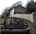
Churchyard and former church, Woodfieldside, Blackwood
Viewed from the edge of St David's Avenue. There is no name on the former church. http://www.geograph.org.uk/photo/4550356 I saw no other churches, former or in use, in St David's Avenue today, so it's likely that this used to be St David's church.
Image: © Jaggery
Taken: 18 Feb 2014
0.05 miles
5
Sirhowy Valley Walk, Woodfieldside
Minor road alongside river, part of the Sirhowy Valley Walk, near Blackwood. The gate in the centre marks the exit from a garden centre.
Image: © M J Roscoe
Taken: 16 Jun 2016
0.06 miles
6
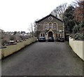
Former church or chapel in Woodfieldside, Blackwood
Viewed from St David's Avenue in February 2014. United Reformed Church (Wales) Trust notices nearby show KEEP OUT - POTENTIAL DANGER Maintenance work in progress, though that warning probably applies to the adjacent churchyard. I saw no other churches, former or in use, in St David's Avenue today, so it's likely that this used to be St David's church.
Image: © Jaggery
Taken: 18 Feb 2014
0.06 miles
7
Rugby ground in Blackwood
Glan-yr-Afon Park is the home ground of Blackwood RFC (Rugby Football Club). Viewed from Hall Street.
Image: © Jaggery
Taken: 18 Feb 2014
0.08 miles
8
River Sirhowy shimmering in sunlight
Looking upstream on the edge of Blackwood; the discoloration in the river in the foreground originates from a small tributary
Image
Image: © M J Roscoe
Taken: 16 Jun 2016
0.08 miles
9
Woodland stream, Sirhowy Valley Walk, Woodfieldside
Hillside stream about to enter culvert under minor road, part of the Sirhowy Valley Walk. This area is part of the River Sirhowy Site of Importance for Nature Conservation.
Image: © M J Roscoe
Taken: 16 Jun 2016
0.09 miles
10
Islwyn grit box, Woodfieldside, Blackwood
Alongside St David's Avenue. The Borough of Islwyn was one of five local government
districts of Gwent from 1974 to 1996. Blackwood is now part of Caerphilly County Borough.
Image: © Jaggery
Taken: 18 Feb 2014
0.10 miles


