IMAGES TAKEN NEAR TO
Halls Crossing, BLACKWOOD, NP12 0PF
Introduction
This page details the photographs taken nearby to Halls Crossing, NP12 0PF by members of the Geograph project.
The Geograph project started in 2005 with the aim of publishing, organising and preserving representative images for every square kilometre of Great Britain, Ireland and the Isle of Man.

There are currently over 7.5m images from over14,400 individuals and you can help contribute to the project by visiting https://www.geograph.org.uk
Image Map
Images are licensed for reuse under creativecommons.org/licenses/by-sa/2.0
Notes
- Clicking on the map will re-center to the selected point.
- The higher the marker number, the further away the image location is from the centre of the postcode.
Image Listing (71 Images Found)
Images are licensed for reuse under creativecommons.org/licenses/by-sa/2.0
Image
Details
Distance
1
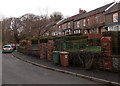
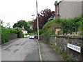
Houses and wheelie bins, St David's Avenue, Woodfieldside, Blackwood
The name on the bins show that they are emptied by Caerphilly County Borough staff.
Image: © Jaggery
Taken: 18 Feb 2014
0.04 miles
2
Former church or chapel in Woodfieldside, Blackwood
Viewed from St David's Avenue in February 2014. United Reformed Church (Wales) Trust notices nearby show KEEP OUT - POTENTIAL DANGER Maintenance work in progress, though that warning probably applies to the adjacent churchyard. I saw no other churches, former or in use, in St David's Avenue today, so it's likely that this used to be St David's church.
Image: © Jaggery
Taken: 18 Feb 2014
0.06 miles
3
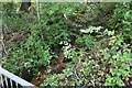
Woodland stream, Sirhowy Valley Walk, Woodfieldside
Hillside stream about to enter culvert under minor road, part of the Sirhowy Valley Walk. This area is part of the River Sirhowy Site of Importance for Nature Conservation.
Image: © M J Roscoe
Taken: 16 Jun 2016
0.06 miles
4
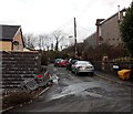
Southern end of St David's Avenue, Woodfieldside, Blackwood
Viewed from Park Terrace.
Image: © Jaggery
Taken: 18 Feb 2014
0.06 miles
6
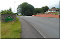
SE boundary of Penmaen
The road from Pontllanfraith reaches Penmaen, a village in Caerphilly county borough,
adjacent to the larger village of Oakdale.
Image: © Jaggery
Taken: 8 Aug 2012
0.07 miles
7
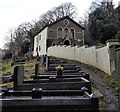
Churchyard and former church, Woodfieldside, Blackwood
Viewed from the edge of St David's Avenue. There is no name on the former church. http://www.geograph.org.uk/photo/4550356 I saw no other churches, former or in use, in St David's Avenue today, so it's likely that this used to be St David's church.
Image: © Jaggery
Taken: 18 Feb 2014
0.07 miles
8
Riverside road to Blackwood Garden Centre
The road from Bridge Street is along the east bank of the Sirhowy.
Image: © Jaggery
Taken: 18 Feb 2014
0.07 miles
9
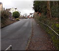
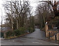
Park Terrace, Woodfieldside, Blackwood
Ascending from the Sirhowy River valley.
Image: © Jaggery
Taken: 18 Feb 2014
0.08 miles
10
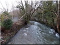
White water on the Sirhowy in Blackwood
Viewed from this http://www.geograph.org.uk/photo/4026716 bridge during a rainy period in January in what was to be the record wet winter of 2013-2014.
Image: © Jaggery
Taken: 18 Feb 2014
0.08 miles