IMAGES TAKEN NEAR TO
Cae'r Garreg, BLACKWOOD, NP12 0PA
Introduction
This page details the photographs taken nearby to Cae'r Garreg, NP12 0PA by members of the Geograph project.
The Geograph project started in 2005 with the aim of publishing, organising and preserving representative images for every square kilometre of Great Britain, Ireland and the Isle of Man.

There are currently over 7.5m images from over14,400 individuals and you can help contribute to the project by visiting https://www.geograph.org.uk
Image Map
Images are licensed for reuse under creativecommons.org/licenses/by-sa/2.0
Notes
- Clicking on the map will re-center to the selected point.
- The higher the marker number, the further away the image location is from the centre of the postcode.
Image Listing (98 Images Found)
Images are licensed for reuse under creativecommons.org/licenses/by-sa/2.0
Image
Details
Distance
1
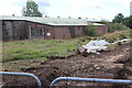
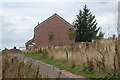
Former golf driving range, Oakdale
The building is about to be demolished to make way for part of a housing estate. The white plastic is part of a reptile exclusion fence.
Image: © M J Roscoe
Taken: 16 Aug 2018
0.01 miles
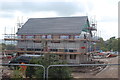
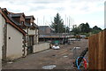
2
Construction site, Sycamore Gardens, Oakdale
Building on the western part of new estate on site of former golf driving range. Some work still continuing. The building on the right is shown in Image
Image: © M J Roscoe
Taken: 29 Apr 2020
0.02 miles
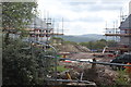
3
House construction, Sycamore Gardens
Building semi-detached houses, probably social housing, on site of former golf driving range.
Image: © M J Roscoe
Taken: 29 Apr 2020
0.02 miles
4
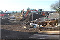
Housing estate construction, Oakdale
Construction of part of housing estate, Sycamore Gardens, on site of former golf driving range. The track in the foreground will be part of the road joining this site to the eastern site Image on the other side of a minor lane (camera position).
Image: © M J Roscoe
Taken: 18 Nov 2019
0.03 miles
5
Path up to end of Cae'R Garreg, Sycamore Gardens
Path up from playground Image on hillside below housing estate.
Image: © M J Roscoe
Taken: 11 Sep 2022
0.03 miles
6
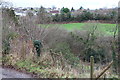
Across the head of Cwm Philkins, Oakdale
Viewed from track to Llys-pentwyn-uchaf farm.
Image: © M J Roscoe
Taken: 5 Feb 2016
0.03 miles
7
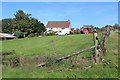
Rear of Gelli-gynnes, Oakdale
The house is on a minor road and the rear field borders the edge of the former golf driving range (right).
Image: © M J Roscoe
Taken: 29 Sep 2018
0.04 miles
8
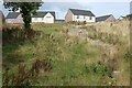
Houses on private driveway off Cae'R Nant, Sycamore Gardens
Houses on top of a hillside on the edge of a new housing estate.
Image: © M J Roscoe
Taken: 11 Sep 2022
0.04 miles
9
House under construction
Construction site behind Bungalow Club, Llwynon Lane.
Image: © M J Roscoe
Taken: 22 Aug 2021
0.05 miles
10
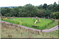
New playground below Sycamore Gardens
Playground on grass on hillside above the Nant Philkins.
Image: © M J Roscoe
Taken: 11 Sep 2022
0.05 miles