IMAGES TAKEN NEAR TO
Cae'r Hen Dy, BLACKWOOD, NP12 0NY
Introduction
This page details the photographs taken nearby to Cae'r Hen Dy, NP12 0NY by members of the Geograph project.
The Geograph project started in 2005 with the aim of publishing, organising and preserving representative images for every square kilometre of Great Britain, Ireland and the Isle of Man.

There are currently over 7.5m images from over14,400 individuals and you can help contribute to the project by visiting https://www.geograph.org.uk
Image Map
Images are licensed for reuse under creativecommons.org/licenses/by-sa/2.0
Notes
- Clicking on the map will re-center to the selected point.
- The higher the marker number, the further away the image location is from the centre of the postcode.
Image Listing (86 Images Found)
Images are licensed for reuse under creativecommons.org/licenses/by-sa/2.0
Image
Details
Distance
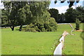
1
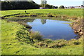
Pond, former golf course, Oakdale
The trees and bushes have been removed from the edge of the pond in preparation for its removal as the area will become part of a housing estate. The pile of rubble (centre background) is the pulverised remains of the clubhouse.
Image: © M J Roscoe
Taken: 29 Sep 2018
0.02 miles
2
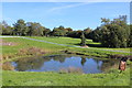
Pond (2), former golf course, Oakdale
Another view of the small pond Image; the trees and bushes around it have removed and the pond will disappear as it will be part of a housing estate. The low plastic fencing marks the edge of the current development and is designed to exclude reptiles from the site.
Image: © M J Roscoe
Taken: 29 Sep 2018
0.02 miles
3
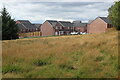
New housing estate, Oakdale
Southern part of housing estate on former golf course; in the foreground is part of the overgrown course.
Image: © M J Roscoe
Taken: 22 Aug 2021
0.02 miles
4
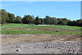
Former golf course, Oakdale
The rubble in the foreground is from the former clubhouse. The low plastic fence near the trees is to exclude reptiles from the site which will become a housing estate, the trees and bushes having been removed leaving scars on the grass.
Image: © M J Roscoe
Taken: 29 Sep 2018
0.02 miles
5
Reptile exclusion fencing, former golf course
Plastic fencing, partly buried, on the former Oakdale Golf Course to prevent the return of reptiles once they have been removed from the area to the left. This area will become part of a housing estate with consequent loss of green space. The trees and bushes in the centre enclose a small pond which will be drained and filled in.
Image: © M J Roscoe
Taken: 16 Aug 2018
0.03 miles
6
Gate on footpath to Sycamore Gardens
To the left of the gate are the remains of the former stile which led formerly to a path between the golf course and a field on the right.
Image: © M J Roscoe
Taken: 26 May 2020
0.03 miles
7
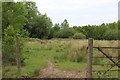
Western part of Nant Philkins Fields, Oakdale
The westernmost field of Nant Philkins Fields Site of Importance for Nature Conservation. The line of the little-used footpath, just to the left of the gateway, is not apparent.
Image: © M J Roscoe
Taken: 25 May 2016
0.03 miles
8
Footpath to Nant Philkins Fields
From the camera the realigned new path crosses new estate road Cae Garw Image At the hedge the path turns to the right for a few yards to reach a gate Image
Image: © M J Roscoe
Taken: 26 May 2020
0.04 miles
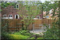
9
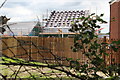
House under construction, Sycamore Gardens
Tiles about to be fixed in position.
Image: © M J Roscoe
Taken: 26 May 2020
0.04 miles
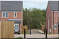
10
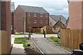
Footpath to Cae Garw, Sycamore Gardens
Slightly realigned path from Nant Philkins Fields to new estate road on former golf course and then to Cae'r Delyn.
Image: © M J Roscoe
Taken: 26 May 2020
0.04 miles