IMAGES TAKEN NEAR TO
Oakdale, BLACKWOOD, NP12 0NP
Introduction
This page details the photographs taken nearby to NP12 0NP by members of the Geograph project.
The Geograph project started in 2005 with the aim of publishing, organising and preserving representative images for every square kilometre of Great Britain, Ireland and the Isle of Man.

There are currently over 7.5m images from over14,400 individuals and you can help contribute to the project by visiting https://www.geograph.org.uk
Image Map
Images are licensed for reuse under creativecommons.org/licenses/by-sa/2.0
Notes
- Clicking on the map will re-center to the selected point.
- The higher the marker number, the further away the image location is from the centre of the postcode.
Image Listing (27 Images Found)
Images are licensed for reuse under creativecommons.org/licenses/by-sa/2.0
Image
Details
Distance
1
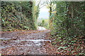
Lane to Cyncoed Farm
Start of lane to farm, viewed from bend in road shown in Image A signposted footpath runs along the road.
Image: © M J Roscoe
Taken: 7 Nov 2015
0.05 miles
2
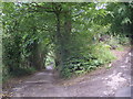
Minor road, Oakdale
Minor road leading from Oakdale up to Cyncoed Farm. Viewpoint is sharp bend in road at junction of lane leading to farm.
Image: © M J Roscoe
Taken: 7 Jul 2015
0.08 miles
3
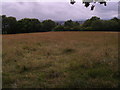
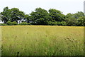
Meadow, Cyncoed Farm
In season this has a stand of the hemiparasitic herb Yellow-rattle,(Rhinanthus sp)
Image: © M J Roscoe
Taken: 12 Jul 2015
0.10 miles
4
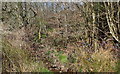
Nant Philkins below Cyncoed Farm
Looking upstream - a small stream running through woodland with a dense understorey, all part of the Coed Cwm Philkins Site of Importance for Nature Conservation.
Image: © M J Roscoe
Taken: 17 Apr 2016
0.11 miles
5
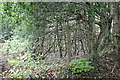
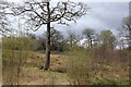
Hillside woodland, north of Cyncoed Farm
An area of young trees next to the minor road leading up to Cyncoed Farm south of Oakdale. The woodland is part of the Coed Cwm Philkins Site of Importance for Nature Conservation.
Image: © M J Roscoe
Taken: 20 May 2016
0.11 miles
6
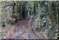
Minor road up from Oakdale
The road is a continuation uphill from the road in Image and is lined mainly by beech trees, originally planted as a hedge.
Image: © M J Roscoe
Taken: 7 Nov 2015
0.11 miles
7
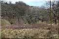
Cwm Philkins below Llys-pentwyn-uchaf
Marshy overgrown pasture near the head of the valley. The line of the little used footpath down to Nant Philkins Image is not apparent. Cincoed Farm is just visible on the skyline.
Image: © M J Roscoe
Taken: 17 Apr 2016
0.15 miles
8
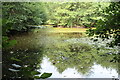
Pond above the Nant Philkins, Oakdale
Oval pond, with small island (top right), enclosed by young deciduous trees.
Image: © M J Roscoe
Taken: 11 Sep 2022
0.15 miles
9
Pasture, Cwm Philkins, below Llys-pentwyn-uchaf
A marshy, somewhat overgrown field; the line of the little used footpath is not apparent and appears to be covered by brambles.
Image: © M J Roscoe
Taken: 24 Apr 2016
0.15 miles
10
Hay meadow, Cyncoed Farm
Meadow with a variety of wild flowers; buttercups are the most obvious, but there are also red clover and the hemiparasite, yellow-rattle. The public footpath crossing the meadow is little used.
Image: © M J Roscoe
Taken: 9 Jun 2016
0.15 miles