IMAGES TAKEN NEAR TO
Manmoel Court, BLACKWOOD, NP12 0NL
Introduction
This page details the photographs taken nearby to Manmoel Court, NP12 0NL by members of the Geograph project.
The Geograph project started in 2005 with the aim of publishing, organising and preserving representative images for every square kilometre of Great Britain, Ireland and the Isle of Man.

There are currently over 7.5m images from over14,400 individuals and you can help contribute to the project by visiting https://www.geograph.org.uk
Image Map
Images are licensed for reuse under creativecommons.org/licenses/by-sa/2.0
Notes
- Clicking on the map will re-center to the selected point.
- The higher the marker number, the further away the image location is from the centre of the postcode.
Image Listing (79 Images Found)
Images are licensed for reuse under creativecommons.org/licenses/by-sa/2.0
Image
Details
Distance
1
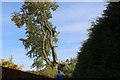
Felling a tree, Oakdale
Progressively felling a tall beech tree at the end of a garden next to a public footpath.
Image: © M J Roscoe
Taken: 21 Oct 2016
0.02 miles
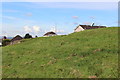
2
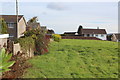
Field at highest point of Oakdale
Looking east towards the end of The Alders
Image: © M J Roscoe
Taken: 21 Oct 2016
0.04 miles
3
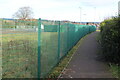
Footpath at rear of Pen-y-Fan Way, Oakdale
Public footpath between new Community Athletics Hub Image and gardens at rear of houses.
Image: © M J Roscoe
Taken: 25 Dec 2020
0.05 miles
4
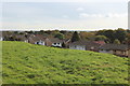
Corner of The Alders & Waun Goch Road, Oakdale
Seen from a small hillside field, the upper storeys of the houses on Waun Goch Road are on the right of the picture.
Image: © M J Roscoe
Taken: 21 Oct 2016
0.06 miles
5
Oakdale - highest point
The top of this small hillside field behind Waun Goch Road is the highest point, 242 m asl, Image in the village.
Image: © M J Roscoe
Taken: 21 Oct 2016
0.07 miles
6
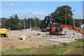
Constructing new athletics ground, Oakdale
Lorry tipping aggregate onto base of athletics track which will be part of Community Athletics Hub.
Image: © M J Roscoe
Taken: 18 Sep 2020
0.07 miles
7
Rear of Rhiw Syr Dafydd Primary School, Oakdale
East end of the school next to the part finished Community Athletics Hub on the site of a former sports field. The path in the foreground leads from a public footpath Image via a gate to the athletics track Image
Image: © M J Roscoe
Taken: 25 Dec 2020
0.07 miles
8
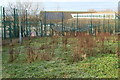
Rhiw Syr Dafydd Primary School, Oakdale
Southeastern side of the rear of the school Image There is a public footpath between the two metal fences.
Image: © M J Roscoe
Taken: 25 Dec 2020
0.07 miles
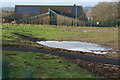
9
Athletics track, Community Athletics Hub
Athletics facility, with six lane track, almost ready for use behind Pen-y-Fan Way. For an earlier view of area under construction - Image
Image: © M J Roscoe
Taken: 25 Dec 2020
0.08 miles
10
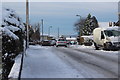
Snow on Waun Goch Road, Oakdale
A residential street on the west of Oakdale two days after about two inches of snow. Caution needed on untreated road when braking!
Image: © M J Roscoe
Taken: 12 Dec 2017
0.08 miles