IMAGES TAKEN NEAR TO
Pen-Rhiw Avenue, BLACKWOOD, NP12 0NH
Introduction
This page details the photographs taken nearby to Pen-Rhiw Avenue, NP12 0NH by members of the Geograph project.
The Geograph project started in 2005 with the aim of publishing, organising and preserving representative images for every square kilometre of Great Britain, Ireland and the Isle of Man.

There are currently over 7.5m images from over14,400 individuals and you can help contribute to the project by visiting https://www.geograph.org.uk
Image Map
Images are licensed for reuse under creativecommons.org/licenses/by-sa/2.0
Notes
- Clicking on the map will re-center to the selected point.
- The higher the marker number, the further away the image location is from the centre of the postcode.
Image Listing (91 Images Found)
Images are licensed for reuse under creativecommons.org/licenses/by-sa/2.0
Image
Details
Distance
1
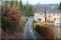
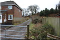
Track down from Llys-pentwyn-uchaf, Oakdale
Farm track between housing estates to Llwyn-on Lane.
Image: © M J Roscoe
Taken: 5 Feb 2016
0.08 miles
2
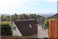
View over Oakdale
View southwest from the highest point in the village, the houses in the foreground are on Maes-y-garn Road.
Image: © M J Roscoe
Taken: 21 Oct 2016
0.08 miles
3
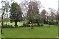
Lawn and bowling green, Oakdale
Birch and other trees in a corner of Oakdale Recreation Ground; an almost opposite view to that in Image
Image: © M J Roscoe
Taken: 6 Dec 2015
0.09 miles
4
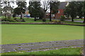
Bowling green in winter, Oakdale
Bowling green, Oakdale Recreation Ground, with Llwyn-on Lane in background.
Image: © M J Roscoe
Taken: 6 Dec 2015
0.09 miles
5
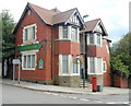
Derelict former pub - The Oakdale, Oakdale
Located in The Square in the centre of Oakdale. Metal sheeting protects the ground floor windows.
The pub appears to have been closed for some time, judging by the faded and broken For Sale sign next to the lamppost.
Image: © Jaggery
Taken: 8 Aug 2012
0.09 miles
6
House under construction
Construction site behind Bungalow Club, Llwynon Lane.
Image: © M J Roscoe
Taken: 22 Aug 2021
0.10 miles
7
Track to Llys-pentwyn-uchaf, Oakdale
Farm track from Llwyn-on Lane, viewed from the gate shown in Image
Image: © M J Roscoe
Taken: 5 Feb 2016
0.10 miles
8
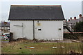
Former Silver Band hut, Oakdale
This derelict outbuilding in the corner of the grounds of the disused Oakdale Hotel Image was used as the rehearsal room for the Oakdale Silver Band. The building is due to be demolished and its site will be used as a private car park for residents of apartments in the revamped Oakdale Hotel.
Image: © M J Roscoe
Taken: 1 Apr 2016
0.10 miles
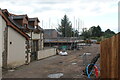
9
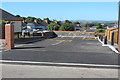
Car park in yard of former Oakdale Hotel
New car park for residents of the three new terraced houses Image and the apartments in the renovated Oakdale Hotel, renamed Oakdale House (all out of shot to right). The Silver Band hut Image stood in the corner of the yard.
Image: © M J Roscoe
Taken: 22 Jun 2018
0.10 miles
10
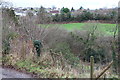
Across the head of Cwm Philkins, Oakdale
Viewed from track to Llys-pentwyn-uchaf farm.
Image: © M J Roscoe
Taken: 5 Feb 2016
0.11 miles