IMAGES TAKEN NEAR TO
Ashville, BLACKWOOD, NP12 0JR
Introduction
This page details the photographs taken nearby to Ashville, NP12 0JR by members of the Geograph project.
The Geograph project started in 2005 with the aim of publishing, organising and preserving representative images for every square kilometre of Great Britain, Ireland and the Isle of Man.

There are currently over 7.5m images from over14,400 individuals and you can help contribute to the project by visiting https://www.geograph.org.uk
Image Map
Images are licensed for reuse under creativecommons.org/licenses/by-sa/2.0
Notes
- Clicking on the map will re-center to the selected point.
- The higher the marker number, the further away the image location is from the centre of the postcode.
Image Listing (68 Images Found)
Images are licensed for reuse under creativecommons.org/licenses/by-sa/2.0
Image
Details
Distance
1
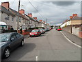
Asheville, Oakdale
The residential street Asheville climbs away from Central Avenue.
Image: © Jaggery
Taken: 8 Aug 2012
0.04 miles
2
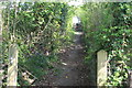
Public footpath up towards West View Crescent
Stone-paved path viewed from below gate Image, now off its hinges.
Image: © M J Roscoe
Taken: 25 Apr 2020
0.07 miles
3
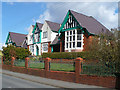
Oakdale Community Hospital
Opened in 1915.
Image: © Robin Drayton
Taken: 5 Apr 2008
0.07 miles
4
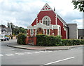
Oakdale Christian Centre
Located on the corner of Central Avenue and Kincoed Road.
Image: © Jaggery
Taken: 8 Aug 2012
0.07 miles
5
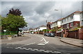
This way to the shops, Oakdale
A sign on the left points along Central Avenue towards the central shopping area.
Image: © Jaggery
Taken: 8 Aug 2012
0.08 miles
6
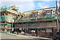
Construction of terraced houses, Central Avenue
A row of three houses in the yard of the former Oakdale Public House (left) for an earlier stage of construction see Image; the rear of the houses is shown in Image The former pub, a Grade II listed building, is being renovated and converted to apartments by a housing association. Use the bus stop to catch the 5 bus to Blackwood.
Image: © M J Roscoe
Taken: 29 Oct 2017
0.09 miles
7
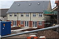
New houses, former Oakdale Public House
Rear of a terrace of three houses, in the yard of the former public house, nearing completion by Pobl Housing Association. For a similar earlier view, see Image
Image: © M J Roscoe
Taken: 8 Apr 2018
0.09 miles
8
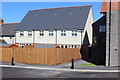
Rear of terraced houses behind former Oakdale Hotel
Row of houses completed in mid June for the Pobl Group. For front view, see Image Part of the former hotel, now Oakdale House, is to the right.
Image: © M J Roscoe
Taken: 22 Jun 2018
0.09 miles
9
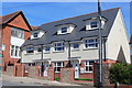
New terraced houses next to Oakdale House
Three houses constructed under the aegis of the Pobl Group next to former Oakdale Hotel, now renovated as Oakdale House, to the left. For rear view of houses, completed in June 2018, see Image The stone walls were built from stone salvaged from the walls that enclosed the hotel yard.
Image: © M J Roscoe
Taken: 24 Jun 2018
0.09 miles
10
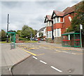
Bus shelters near the southern edge of The Square, Oakdale
Viewed along Central Avenue. On the right is the derelict former Oakdale pub. http://www.geograph.org.uk/photo/3075949
Image: © Jaggery
Taken: 8 Aug 2012
0.09 miles